Rājnagar geodata
Rājnagar (Madhya Pradesh) is a populated place; located in India in Asia/Kolkata (GMT+5.5) time zone. With population of 13,390 people, there are 2619 cities with bigger population in this country. Compared to other cities in India, 62.9% of cities are located further ↓South; 67.2% of cities are located further ←West and 55.6% of cities have lower elevation than Rājnagar. Note1


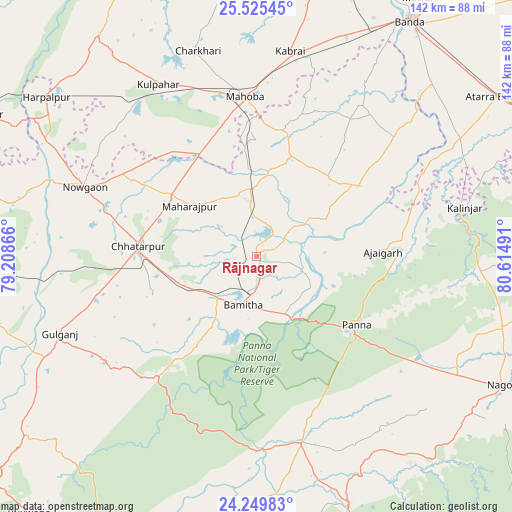
Rājnagar GPS coordinates[2]
24° 53' 21.444" North, 79° 54' 42.408" East
| Map corner | latitude | longitude |
|---|---|---|
| Upper-left | 25.52545°, | 79.20866° |
| Center: | 24.88929°, | 79.91178° |
| Lower-right: | 24.24983°, | 80.61491° |
| Map W x H: | 141.8×141.8 km | = 88.1×88.1mi |
| max Lat: | 34.9274° ⇑37.1% North |
| Rājnagar: | 24.88929° |
| min Lat: | ⇓62.9% South 8.09008° |
| min Long | Rājnagar | max Long |
| 68.82655° | 79.91178° | 96.81° |
| W 67.2%⇐ | ⇒32.8% E |
Elevation
Elevation of Rājnagar is 228 m = 748 ft, and this is 67.6 m = 222 ft below average elevation for this country.
| Max E: |
3681 m = 12077 ft | 44.4% |
| Avg. | 295.6 m = 970 ft | |
| Rājnagar | 228 m = 748 ft | |
Min E: |
1 m = 3 ft | 55.6% |
See also: India elevation on elevation.city.
Geographical zone
Rājnagar is located in North temperate zone (between Tropic of Cancer and the Arctic Circle). Distance of this Northern Tropic circle is 161.5 km =100.4 mi to South.| Distance of | km | miles | from Rājnagar |
|---|---|---|---|
| North Pole | 7239.6 | 4498.5 | to North |
| Arctic Circle | 4633.7 | 2879.2 | to North |
| Tropic Cancer | 161.5 | 100.4 | to South |
| Equator | 2767.4 | 1719.6 | to South |


Nearby cities:
15 places around Rājnagar: (largest is in red/bold)
• Ajaigarh
35.1 km =21.8 mi,  88°
88°
• Amānganj
52.9 km =32.9 mi,  166°
166°
• Bijāwar
51.8 km =32.2 mi,  235°
235°
• Chandla
34.8 km =21.6 mi,  54°
54°
• Charkhāri
59.4 km =36.9 mi,  343°
343°
• Chhatarpur
32.7 km =20.3 mi,  275°
275°
• Harpālpur
73.2 km =45.5 mi,  307°
307°
• Kabrāi
57.8 km =35.9 mi,  8°
8°
• Khajuraho Group of Monuments
5.1 km =3.2 mi,  154°
154°
• Kulpahār
55.2 km =34.3 mi,  330°
330°
• Mahobā
44.8 km =27.8 mi,  355°
355°
• Mataundh
65.6 km =40.8 mi,  22°
22°
• Naraini
65.9 km =40.9 mi,  59°
59°
• Palera
70.4 km =43.7 mi, 281°
• Panna
33.6 km =20.9 mi,  123°
123°
Sources, notices
• [Note1] Compared only with cities in India existing in our database
• [Src1] Map data: © OpenStreetMap contributors (CC-BY-SA)
• [Src2] Other city data from geonames.org with taken over terms of usage.
• [Src3] Geographical zone / Annual Mean Temperature by Robert A. Rohde @ Wikipedia
