Chandla geodata
Chandla (Madhya Pradesh) is a populated place; located in India in Asia/Kolkata (GMT+5.5) time zone. With population of 11,195 people, there are 2814 cities with bigger population in this country. Compared to other cities in India, 63.9% of cities are located further ↓South; 69.5% of cities are located further ←West and 53.8% of cities have higher elevation than Chandla. Note1


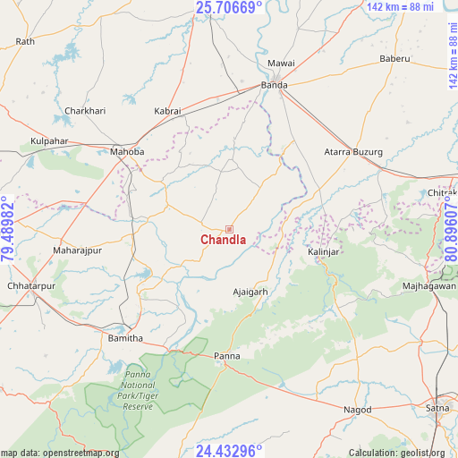
Chandla GPS coordinates[2]
25° 4' 17.328" North, 80° 11' 34.584" East
| Map corner | latitude | longitude |
|---|---|---|
| Upper-left | 25.70669°, | 79.48982° |
| Center: | 25.07148°, | 80.19294° |
| Lower-right: | 24.43296°, | 80.89607° |
| Map W x H: | 141.6×141.6 km | = 88×88mi |
| max Lat: | 34.9274° ⇑36.1% North |
| Chandla: | 25.07148° |
| min Lat: | ⇓63.9% South 8.09008° |
| min Long | Chandla | max Long |
| 68.82655° | 80.19294° | 96.81° |
| W 69.5%⇐ | ⇒30.5% E |
Elevation
Elevation of Chandla is 181 m = 594 ft, and this is 114.6 m = 376 ft below average elevation for this country.
| Max E: |
3681 m = 12077 ft | 53.8% |
| Avg. | 295.6 m = 970 ft | |
| Chandla | 181 m = 594 ft | |
Min E: |
1 m = 3 ft | 46.2% |
See also: India elevation on elevation.city.
Geographical zone
Chandla is located in North temperate zone (between Tropic of Cancer and the Arctic Circle). Distance of this Northern Tropic circle is 181.8 km =113 mi to South.| Distance of | km | miles | from Chandla |
|---|---|---|---|
| North Pole | 7219.4 | 4485.9 | to North |
| Arctic Circle | 4613.5 | 2866.7 | to North |
| Tropic Cancer | 181.8 | 113 | to South |
| Equator | 2787.7 | 1732.2 | to South |


Nearby cities:
15 places around Chandla: (largest is in red/bold)
• Ajaigarh
20.3 km =12.6 mi,  160°
160°
• Atarra
45 km =28 mi,  57°
57°
• Bisenda Buzurg
56.6 km =35.2 mi,  49°
49°
• Bānda
47.4 km =29.5 mi,  17°
17°
• Charkhāri
57.9 km =36 mi,  309°
309°
• Chhatarpur
63.2 km =39.3 mi,  254°
254°
• Kabrāi
41.7 km =25.9 mi,  332°
332°
• Khajuraho Group of Monuments
36.1 km =22.4 mi,  226°
226°
• Kulpahār
62.2 km =38.6 mi,  296°
296°
• Mahobā
40.2 km =25 mi, 307°
• Mataundh
40.7 km =25.3 mi,  354°
354°
• Naraini
31.3 km =19.4 mi,  65°
65°
• Oran
64.4 km =40 mi, 59°
• Panna
39 km =24.2 mi,  180°
180°
• Rājnagar
34.8 km =21.6 mi, 234°
Sources, notices
• [Note1] Compared only with cities in India existing in our database
• [Src1] Map data: © OpenStreetMap contributors (CC-BY-SA)
• [Src2] Other city data from geonames.org with taken over terms of usage.
• [Src3] Geographical zone / Annual Mean Temperature by Robert A. Rohde @ Wikipedia
