Hānsi geodata
Hānsi (Haryana) is a populated place; located in India in Asia/Kolkata (GMT+5.5) time zone. With population of 82,407 people, there are 534 cities with bigger population in this country. Compared to other cities in India, 89.2% of cities are located further ↓South; 73.9% of cities are located further →East and 54.7% of cities have lower elevation than Hānsi. Note1


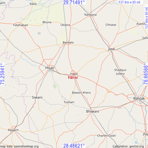
Hānsi GPS coordinates[2]
29° 6' 8.604" North, 75° 57' 45.108" East
| Map corner | latitude | longitude |
|---|---|---|
| Upper-left | 29.71491°, | 75.25941° |
| Center: | 29.10239°, | 75.96253° |
| Lower-right: | 28.48621°, | 76.66566° |
| Map W x H: | 136.6×136.6 km | = 84.9×84.9mi |
| max Lat: | 34.9274° ⇑10.8% North |
| Hānsi: | 29.10239° |
| min Lat: | ⇓89.2% South 8.09008° |
| min Long | Hānsi | max Long |
| 68.82655° | 75.96253° | 96.81° |
| W 26.1%⇐ | ⇒73.9% E |
Elevation
Elevation of Hānsi is 225 m = 738 ft, and this is 70.6 m = 232 ft below average elevation for this country.
| Max E: |
3681 m = 12077 ft | 45.3% |
| Avg. | 295.6 m = 970 ft | |
| Hānsi | 225 m = 738 ft | |
Min E: |
1 m = 3 ft | 54.7% |
See also: Hānsi elevation on elevation.city.
Geographical zone
Hānsi is located in North temperate zone (between Tropic of Cancer and the Arctic Circle). Distance of this Northern Tropic circle is 630 km =391.5 mi to South.| Distance of | km | miles | from Hānsi |
|---|---|---|---|
| North Pole | 6771.2 | 4207.4 | to North |
| Arctic Circle | 4165.3 | 2588.2 | to North |
| Tropic Cancer | 630 | 391.5 | to South |
| Equator | 3235.9 | 2010.7 | to South |


Nearby cities:
15 places around Hānsi: (largest is in red/bold)
• Bara Uchāna
45.7 km =28.4 mi,  27°
27°
• Barwāla
29.9 km =18.6 mi,  349°
349°
• Bhiwāni
38.5 km =23.9 mi,  153°
153°
• Gorakhpur
47.6 km =29.6 mi,  323°
323°
• Hisar
24 km =14.9 mi,  283°
283°
• Inda Chhoi
62.1 km =38.6 mi,  344°
344°
• Jīnd
41.6 km =25.8 mi,  55°
55°
• Kalānaur
52 km =32.3 mi,  125°
125°
• Maham
35.6 km =22.1 mi,  114°
114°
• Mandholi Kalān
51.6 km =32.1 mi,  211°
211°
• Narwāna
57.3 km =35.6 mi,  15°
15°
• Nārnaund
21.9 km =13.6 mi,  53°
53°
• Shādīpur Julāna
43.1 km =26.8 mi,  86°
86°
• Toshām
26.2 km =16.3 mi,  189°
189°
• Uklāna
46.2 km =28.7 mi, 349°
Sources, notices
• [Note1] Compared only with cities in India existing in our database
• [Src1] Map data: © OpenStreetMap contributors (CC-BY-SA)
• [Src2] Other city data from geonames.org with taken over terms of usage.
• [Src3] Geographical zone / Annual Mean Temperature by Robert A. Rohde @ Wikipedia
