Toshām geodata
Toshām (Haryana) is a populated place; located in India in Asia/Kolkata (GMT+5.5) time zone. With population of 12,528 people, there are 2696 cities with bigger population in this country. Compared to other cities in India, 88.6% of cities are located further ↓South; 74.5% of cities are located further →East and 51.9% of cities have lower elevation than Toshām. Note1


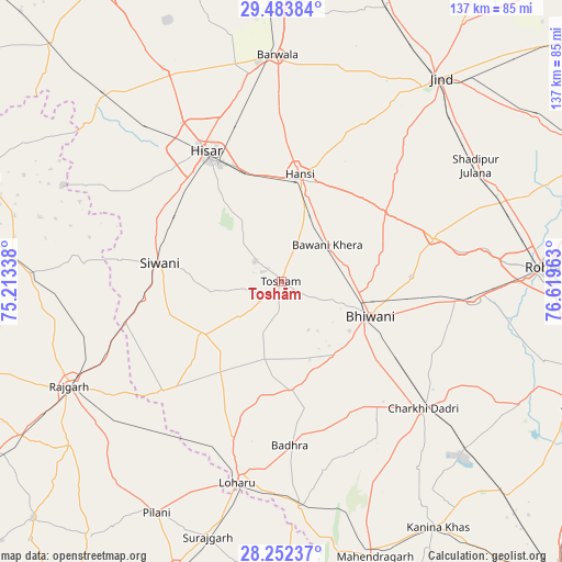
Toshām GPS coordinates[2]
28° 52' 11.748" North, 75° 54' 59.4" East
| Map corner | latitude | longitude |
|---|---|---|
| Upper-left | 29.48384°, | 75.21338° |
| Center: | 28.86993°, | 75.9165° |
| Lower-right: | 28.25237°, | 76.61963° |
| Map W x H: | 136.9×136.9 km | = 85.1×85.1mi |
| max Lat: | 34.9274° ⇑11.4% North |
| Toshām: | 28.86993° |
| min Lat: | ⇓88.6% South 8.09008° |
| min Long | Toshām | max Long |
| 68.82655° | 75.9165° | 96.81° |
| W 25.5%⇐ | ⇒74.5% E |
Elevation
Elevation of Toshām is 213 m = 699 ft, and this is 82.6 m = 271 ft below average elevation for this country.
| Max E: |
3681 m = 12077 ft | 48.1% |
| Avg. | 295.6 m = 970 ft | |
| Toshām | 213 m = 699 ft | |
Min E: |
1 m = 3 ft | 51.9% |
See also: India elevation on elevation.city.
Geographical zone
Toshām is located in North temperate zone (between Tropic of Cancer and the Arctic Circle). Distance of this Northern Tropic circle is 604.1 km =375.4 mi to South.| Distance of | km | miles | from Toshām |
|---|---|---|---|
| North Pole | 6797 | 4223.5 | to North |
| Arctic Circle | 4191.1 | 2604.2 | to North |
| Tropic Cancer | 604.1 | 375.4 | to South |
| Equator | 3210 | 1994.6 | to South |


Nearby cities:
15 places around Toshām: (largest is in red/bold)
• Barwāla
55.3 km =34.4 mi,  359°
359°
• Bhiwāni
23.4 km =14.5 mi,  111°
111°
• Charkhi Dādri
46.4 km =28.8 mi,  131°
131°
• Hisar
36.8 km =22.9 mi,  329°
329°
• Hānsi
26.2 km =16.3 mi,  9°
9°
• Jīnd
62.9 km =39.1 mi,  37°
37°
• Kalānaur
46.9 km =29.1 mi,  95°
95°
• Lohāru
50.1 km =31.1 mi,  192°
192°
• Maham
38.4 km =23.9 mi,  73°
73°
• Mandholi Kalān
29 km =18 mi,  231°
231°
• Nārnaund
44.8 km =27.8 mi,  29°
29°
• Pilāni
63.7 km =39.6 mi,  208°
208°
• Rājgarh
57.6 km =35.8 mi,  243°
243°
• Shādīpur Julāna
55.3 km =34.4 mi,  59°
59°
• Sūrajgarh
64.8 km =40.3 mi,  196°
196°
Sources, notices
• [Note1] Compared only with cities in India existing in our database
• [Src1] Map data: © OpenStreetMap contributors (CC-BY-SA)
• [Src2] Other city data from geonames.org with taken over terms of usage.
• [Src3] Geographical zone / Annual Mean Temperature by Robert A. Rohde @ Wikipedia
