Jaynagar geodata
Jaynagar (Bihar) is a populated place; located in India in Asia/Kolkata (GMT+5.5) time zone. With population of 20,496 people, there are 2001 cities with bigger population in this country. Compared to other cities in India, 75.4% of cities are located further ↓South; 87.3% of cities are located further ←West and 73.6% of cities have higher elevation than Jaynagar. Note1


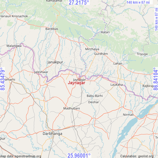
Jaynagar GPS coordinates[2]
26° 35' 25.728" North, 86° 8' 16.476" East
| Map corner | latitude | longitude |
|---|---|---|
| Upper-left | 27.2175°, | 85.43479° |
| Center: | 26.59048°, | 86.13791° |
| Lower-right: | 25.96001°, | 86.84104° |
| Map W x H: | 139.8×139.8 km | = 86.9×86.9mi |
| max Lat: | 34.9274° ⇑24.6% North |
| Jaynagar: | 26.59048° |
| min Lat: | ⇓75.4% South 8.09008° |
| min Long | Jaynagar | max Long |
| 68.82655° | 86.13791° | 96.81° |
| W 87.3%⇐ | ⇒12.7% E |
Elevation
Elevation of Jaynagar is 76 m = 249 ft, and this is 219.6 m = 720 ft below average elevation for this country.
| Max E: |
3681 m = 12077 ft | 73.6% |
| Avg. | 295.6 m = 970 ft | |
| Jaynagar | 76 m = 249 ft | |
Min E: |
1 m = 3 ft | 26.4% |
See also: India elevation on elevation.city.
Geographical zone
Jaynagar is located in North temperate zone (between Tropic of Cancer and the Arctic Circle). Distance of this Northern Tropic circle is 350.7 km =217.9 mi to South.| Distance of | km | miles | from Jaynagar |
|---|---|---|---|
| North Pole | 7050.5 | 4381 | to North |
| Arctic Circle | 4444.6 | 2761.7 | to North |
| Tropic Cancer | 350.7 | 217.9 | to South |
| Equator | 2956.6 | 1837.1 | to South |


Nearby cities:
15 places around Jaynagar: (largest is in red/bold)
• Bairāgnia
87.5 km =54.4 mi,  280°
280°
• Bangaon
88.6 km =55.1 mi,  155°
155°
• Belsand
75.1 km =46.7 mi,  257°
257°
• Bhagirathpur
36.5 km =22.7 mi,  191°
191°
• Bīrpur
87.4 km =54.3 mi,  96°
96°
• Darbhanga
54.3 km =33.7 mi,  206°
206°
• Dumra
61.5 km =38.2 mi,  267°
267°
• Jhanjhārpur
38.9 km =24.2 mi, 158°
• Madhubani
27.1 km =16.8 mi, 194°
• Nirmāli
54.1 km =33.6 mi,  124°
124°
• Pupri
45.3 km =28.1 mi,  252°
252°
• Samāstipur
88.5 km =55 mi,  203°
203°
• Sheohar
84.4 km =52.4 mi, 264°
• Supaul
69.8 km =43.4 mi,  139°
139°
• Sītāmarhi
64.4 km =40 mi, 270°
Sources, notices
• [Note1] Compared only with cities in India existing in our database
• [Src1] Map data: © OpenStreetMap contributors (CC-BY-SA)
• [Src2] Other city data from geonames.org with taken over terms of usage.
• [Src3] Geographical zone / Annual Mean Temperature by Robert A. Rohde @ Wikipedia
