Baldeogarh geodata
Baldeogarh (Madhya Pradesh) is a populated place; located in India in Asia/Kolkata (GMT+5.5) time zone. With population of 8,282 people, there are 3101 cities with bigger population in this country. Compared to other cities in India, 62.1% of cities are located further ↓South; 59.5% of cities are located further ←West and 71.4% of cities have lower elevation than Baldeogarh. Note1


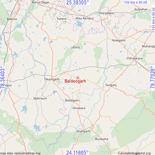
Baldeogarh GPS coordinates[2]
24° 45' 22.284" North, 79° 4' 1.74" East
| Map corner | latitude | longitude |
|---|---|---|
| Upper-left | 25.39305°, | 78.36403° |
| Center: | 24.75619°, | 79.06715° |
| Lower-right: | 24.11605°, | 79.77028° |
| Map W x H: | 142×142 km | = 88.2×88.2mi |
| max Lat: | 34.9274° ⇑37.9% North |
| Baldeogarh: | 24.75619° |
| min Lat: | ⇓62.1% South 8.09008° |
| min Long | Baldeogarh | max Long |
| 68.82655° | 79.06715° | 96.81° |
| W 59.5%⇐ | ⇒40.5% E |
Elevation
Elevation of Baldeogarh is 341 m = 1119 ft, and this is 45.4 m = 149 ft above average elevation for this country.
| Max E: |
3681 m = 12077 ft | 28.6% |
| Baldeogarh | 341 m 1119 ft | |
| Avg. | 295.6 m = 970 ft | |
Min E: |
1 m = 3 ft | 71.4% |
See also: India elevation on elevation.city.
Geographical zone
Baldeogarh is located in North temperate zone (between Tropic of Cancer and the Arctic Circle). Distance of this Northern Tropic circle is 146.7 km =91.2 mi to South.| Distance of | km | miles | from Baldeogarh |
|---|---|---|---|
| North Pole | 7254.4 | 4507.7 | to North |
| Arctic Circle | 4648.5 | 2888.4 | to North |
| Tropic Cancer | 146.7 | 91.2 | to South |
| Equator | 2752.6 | 1710.4 | to South |


Nearby cities:
15 places around Baldeogarh: (largest is in red/bold)
• Bakshwāho
60.4 km =37.5 mi,  158°
158°
• Bijāwar
45.2 km =28.1 mi,  109°
109°
• Chhatarpur
55.6 km =34.5 mi,  71°
71°
• Harpālpur
64.9 km =40.3 mi,  24°
24°
• Jatāra
28.2 km =17.5 mi,  356°
356°
• Khargāpur
10.7 km =6.6 mi,  46°
46°
• Lalitpur
65.9 km =40.9 mi,  263°
263°
• Mahroni
39.2 km =24.4 mi,  241°
241°
• Palera
33.5 km =20.8 mi,  28°
28°
• Pāli
72.1 km =44.8 mi,  245°
245°
• Rānīpur
54.9 km =34.1 mi, 359°
• Shāhgarh
49.5 km =30.8 mi,  174°
174°
• Tori-Fatehpur
77.9 km =48.4 mi,  3°
3°
• Tālbahat
71.4 km =44.4 mi,  296°
296°
• Tīkamgarh
23.9 km =14.9 mi,  266°
266°
Sources, notices
• [Note1] Compared only with cities in India existing in our database
• [Src1] Map data: © OpenStreetMap contributors (CC-BY-SA)
• [Src2] Other city data from geonames.org with taken over terms of usage.
• [Src3] Geographical zone / Annual Mean Temperature by Robert A. Rohde @ Wikipedia
