Chhatarpur geodata
Chhatarpur (Madhya Pradesh) is a populated place; located in India in Asia/Kolkata (GMT+5.5) time zone. With population of 111,594 people, there are 399 cities with bigger population in this country. Compared to other cities in India, 63% of cities are located further ↓South; 64.6% of cities are located further ←West and 68.4% of cities have lower elevation than Chhatarpur. Note1


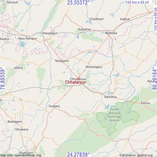
Chhatarpur GPS coordinates[2]
24° 55' 3.72" North, 79° 35' 19.356" East
| Map corner | latitude | longitude |
|---|---|---|
| Upper-left | 25.55372°, | 78.88559° |
| Center: | 24.9177°, | 79.58871° |
| Lower-right: | 24.27839°, | 80.29184° |
| Map W x H: | 141.8×141.8 km | = 88.1×88.1mi |
| max Lat: | 34.9274° ⇑37% North |
| Chhatarpur: | 24.9177° |
| min Lat: | ⇓63% South 8.09008° |
| min Long | Chhatarpur | max Long |
| 68.82655° | 79.58871° | 96.81° |
| W 64.6%⇐ | ⇒35.4% E |
Elevation
Elevation of Chhatarpur is 311 m = 1020 ft, and this is 15.4 m = 51 ft above average elevation for this country.
| Max E: |
3681 m = 12077 ft | 31.6% |
| Chhatarpur | 311 m 1020 ft | |
| Avg. | 295.6 m = 970 ft | |
Min E: |
1 m = 3 ft | 68.4% |
See also: Chhatarpur elevation on elevation.city.
Geographical zone
Chhatarpur is located in North temperate zone (between Tropic of Cancer and the Arctic Circle). Distance of this Northern Tropic circle is 164.7 km =102.3 mi to South.| Distance of | km | miles | from Chhatarpur |
|---|---|---|---|
| North Pole | 7236.5 | 4496.6 | to North |
| Arctic Circle | 4630.6 | 2877.3 | to North |
| Tropic Cancer | 164.7 | 102.3 | to South |
| Equator | 2770.6 | 1721.6 | to South |


Nearby cities:
15 places around Chhatarpur: (largest is in red/bold)
• Ajaigarh
67.7 km =42.1 mi,  91°
91°
• Baldeogarh
55.6 km =34.5 mi,  251°
251°
• Bijāwar
34.2 km =21.3 mi,  196°
196°
• Chandla
63.2 km =39.3 mi,  74°
74°
• Charkhāri
56.3 km =35 mi,  16°
16°
• Harpālpur
48.5 km =30.1 mi,  327°
327°
• Jatāra
55.4 km =34.4 mi,  280°
280°
• Khajuraho Group of Monuments
35.6 km =22.1 mi,  102°
102°
• Khargāpur
46.1 km =28.6 mi,  256°
256°
• Kulpahār
45 km =28 mi,  6°
6°
• Mahobā
50.5 km =31.4 mi,  34°
34°
• Palera
38.1 km =23.7 mi,  287°
287°
• Panna
64.3 km =40 mi,  109°
109°
• Rājnagar
32.7 km =20.3 mi, 95°
• Rānīpur
64.7 km =40.2 mi,  304°
304°
Sources, notices
• [Note1] Compared only with cities in India existing in our database
• [Src1] Map data: © OpenStreetMap contributors (CC-BY-SA)
• [Src2] Other city data from geonames.org with taken over terms of usage.
• [Src3] Geographical zone / Annual Mean Temperature by Robert A. Rohde @ Wikipedia
