Jālna geodata
Jālna (Maharashtra) is a populated place; located in India in Asia/Kolkata (GMT+5.5) time zone. With population of 262,034 people, there are 160 cities with bigger population in this country. Compared to other cities in India, 65.9% of cities are located further ↑North; 74.8% of cities are located further →East and 82.9% of cities have lower elevation than Jālna. Note1


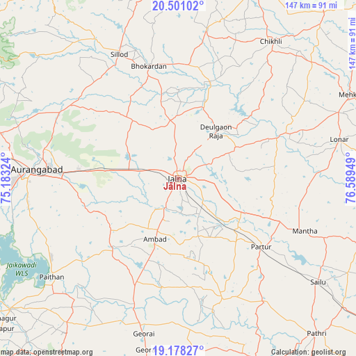
Jālna GPS coordinates[2]
19° 50' 27.672" North, 75° 53' 10.896" East
| Map corner | latitude | longitude |
|---|---|---|
| Upper-left | 20.50102°, | 75.18324° |
| Center: | 19.84102°, | 75.88636° |
| Lower-right: | 19.17827°, | 76.58949° |
| Map W x H: | 147.1×147.1 km | = 91.4×91.4mi |
| max Lat: | 34.9274° ⇑65.9% North |
| Jālna: | 19.84102° |
| min Lat: | ⇓34.1% South 8.09008° |
| min Long | Jālna | max Long |
| 68.82655° | 75.88636° | 96.81° |
| W 25.2%⇐ | ⇒74.8% E |
Elevation
Elevation of Jālna is 504 m = 1654 ft, and this is 208.4 m = 684 ft above average elevation for this country.
| Max E: |
3681 m = 12077 ft | 17.1% |
| Jālna | 504 m 1654 ft | |
| Avg. | 295.6 m = 970 ft | |
Min E: |
1 m = 3 ft | 82.9% |
See also: Jālna elevation on elevation.city.
Geographical zone
Jālna is located in North Torrid zone (between Equator and Tropic of Cancer). Distance of this Northern Tropic circle is 399.8 km =248.4 mi to North.| Distance of | km | miles | from Jālna |
|---|---|---|---|
| North Pole | 7800.9 | 4847.3 | to North |
| Arctic Circle | 5195.1 | 3228.1 | to North |
| Tropic Cancer | 399.8 | 248.4 | to North |
| Equator | 2206.1 | 1370.8 | to South |


Nearby cities:
15 places around Jālna: (largest is in red/bold)
• Ambad
27.3 km =17 mi,  201°
201°
• Ashti
62.6 km =38.9 mi,  145°
145°
• Aurangabad
57 km =35.4 mi,  274°
274°
• Chikhli
68.6 km =42.6 mi,  34°
34°
• Daulatābād
70.3 km =43.7 mi,  278°
278°
• Deūlgaon Rāja
25.2 km =15.7 mi,  38°
38°
• Ellora
78.3 km =48.7 mi, 284°
• Gevrai
65.8 km =40.9 mi,  192°
192°
• Khuldābād
74.8 km =46.5 mi, 284°
• Lonār
68.2 km =42.4 mi,  76°
76°
• Paithan
66.4 km =41.3 mi,  232°
232°
• Partūr
43.7 km =27.2 mi,  127°
127°
• Pīpri
37.1 km =23.1 mi,  261°
261°
• Selu
72.2 km =44.9 mi, 126°
• Sillod
56.9 km =35.4 mi,  334°
334°
Sources, notices
• [Note1] Compared only with cities in India existing in our database
• [Src1] Map data: © OpenStreetMap contributors (CC-BY-SA)
• [Src2] Other city data from geonames.org with taken over terms of usage.
• [Src3] Geographical zone / Annual Mean Temperature by Robert A. Rohde @ Wikipedia
