Ambad geodata
Ambad (Maharashtra) is a populated place; located in India in Asia/Kolkata (GMT+5.5) time zone. With population of 29,846 people, there are 1452 cities with bigger population in this country. Compared to other cities in India, 66.6% of cities are located further ↑North; 75.8% of cities are located further →East and 83.2% of cities have lower elevation than Ambad. Note1


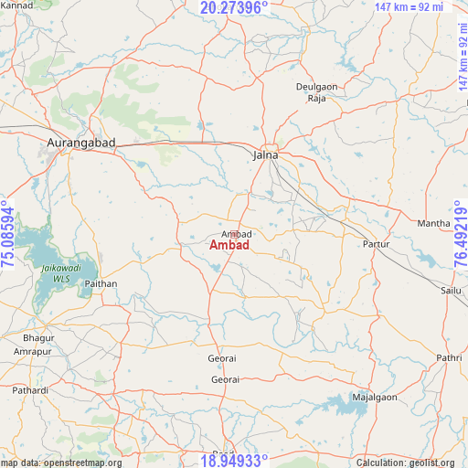
Ambad GPS coordinates[2]
19° 36' 46.836" North, 75° 47' 20.616" East
| Map corner | latitude | longitude |
|---|---|---|
| Upper-left | 20.27396°, | 75.08594° |
| Center: | 19.61301°, | 75.78906° |
| Lower-right: | 18.94933°, | 76.49219° |
| Map W x H: | 147.3×147.3 km | = 91.5×91.5mi |
| max Lat: | 34.9274° ⇑66.6% North |
| Ambad: | 19.61301° |
| min Lat: | ⇓33.4% South 8.09008° |
| min Long | Ambad | max Long |
| 68.82655° | 75.78906° | 96.81° |
| W 24.2%⇐ | ⇒75.8% E |
Elevation
Elevation of Ambad is 512 m = 1680 ft, and this is 216.4 m = 710 ft above average elevation for this country.
| Max E: |
3681 m = 12077 ft | 16.8% |
| Ambad | 512 m 1680 ft | |
| Avg. | 295.6 m = 970 ft | |
Min E: |
1 m = 3 ft | 83.2% |
See also: India elevation on elevation.city.
Geographical zone
Ambad is located in North Torrid zone (between Equator and Tropic of Cancer). Distance of this Northern Tropic circle is 425.2 km =264.2 mi to North.| Distance of | km | miles | from Ambad |
|---|---|---|---|
| North Pole | 7826.3 | 4863 | to North |
| Arctic Circle | 5220.4 | 3243.8 | to North |
| Tropic Cancer | 425.2 | 264.2 | to North |
| Equator | 2180.8 | 1355.1 | to South |


Nearby cities:
15 places around Ambad: (largest is in red/bold)
• Ashti
52.7 km =32.7 mi,  119°
119°
• Aurangabad
55.2 km =34.3 mi,  302°
302°
• Beed
69.4 km =43.1 mi,  182°
182°
• Daulatābād
69.4 km =43.1 mi, 301°
• Deūlgaon Rāja
52 km =32.3 mi,  30°
30°
• Gevrai
39.1 km =24.3 mi,  186°
186°
• Jālna
27.3 km =17 mi,  21°
21°
• Khuldābād
76.2 km =47.3 mi,  305°
305°
• Mājalgaon
66.9 km =41.6 mi,  138°
138°
• Paithan
45 km =28 mi,  250°
250°
• Partūr
44.7 km =27.8 mi,  91°
91°
• Pāthri
78.3 km =48.7 mi, 120°
• Pīpri
33.3 km =20.7 mi, 307°
• Selu
70.5 km =43.8 mi,  104°
104°
• Sillod
78 km =48.5 mi,  349°
349°
Sources, notices
• [Note1] Compared only with cities in India existing in our database
• [Src1] Map data: © OpenStreetMap contributors (CC-BY-SA)
• [Src2] Other city data from geonames.org with taken over terms of usage.
• [Src3] Geographical zone / Annual Mean Temperature by Robert A. Rohde @ Wikipedia
