Lonār geodata
Lonār (Maharashtra) is a populated place; located in India in Asia/Kolkata (GMT+5.5) time zone. With population of 21,765 people, there are 1916 cities with bigger population in this country. Compared to other cities in India, 65.2% of cities are located further ↑North; 68.2% of cities are located further →East and 88.6% of cities have lower elevation than Lonār. Note1


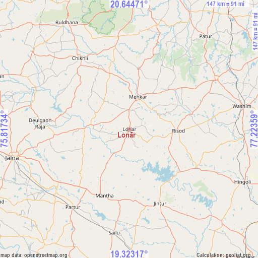
Lonār GPS coordinates[2]
19° 59' 7.188" North, 76° 31' 13.656" East
| Map corner | latitude | longitude |
|---|---|---|
| Upper-left | 20.64471°, | 75.81734° |
| Center: | 19.98533°, | 76.52046° |
| Lower-right: | 19.32317°, | 77.22359° |
| Map W x H: | 146.9×146.9 km | = 91.3×91.3mi |
| max Lat: | 34.9274° ⇑65.2% North |
| Lonār: | 19.98533° |
| min Lat: | ⇓34.8% South 8.09008° |
| min Long | Lonār | max Long |
| 68.82655° | 76.52046° | 96.81° |
| W 31.8%⇐ | ⇒68.2% E |
Elevation
Elevation of Lonār is 604 m = 1982 ft, and this is 308.4 m = 1012 ft above average elevation for this country.
| Max E: |
3681 m = 12077 ft | 11.4% |
| Lonār | 604 m 1982 ft | |
| Avg. | 295.6 m = 970 ft | |
Min E: |
1 m = 3 ft | 88.6% |
See also: India elevation on elevation.city.
Geographical zone
Lonār is located in North Torrid zone (between Equator and Tropic of Cancer). Distance of this Northern Tropic circle is 383.8 km =238.5 mi to North.| Distance of | km | miles | from Lonār |
|---|---|---|---|
| North Pole | 7784.9 | 4837.3 | to North |
| Arctic Circle | 5179 | 3218.1 | to North |
| Tropic Cancer | 383.8 | 238.5 | to North |
| Equator | 2222.2 | 1380.8 | to South |


Nearby cities:
15 places around Lonār: (largest is in red/bold)
• Ashti
74.4 km =46.2 mi,  204°
204°
• Buldāna
69.9 km =43.4 mi,  329°
329°
• Bālāpur
80.2 km =49.8 mi,  19°
19°
• Chikhli
49 km =30.4 mi, 325°
• Deūlgaon Rāja
50.6 km =31.4 mi,  274°
274°
• Hingoli
71.7 km =44.6 mi,  114°
114°
• Jintūr
45 km =28 mi,  157°
157°
• Jālna
68.2 km =42.4 mi,  256°
256°
• Mehekar
19 km =11.8 mi, 15°
• Mānwat
76.1 km =47.3 mi,  181°
181°
• Partūr
53.5 km =33.2 mi,  216°
216°
• Pātūr
68.5 km =42.6 mi,  39°
39°
• Risod
28 km =17.4 mi,  91°
91°
• Selu
59.5 km =37 mi,  188°
188°
• Wāshīm
65.5 km =40.7 mi,  77°
77°
Sources, notices
• [Note1] Compared only with cities in India existing in our database
• [Src1] Map data: © OpenStreetMap contributors (CC-BY-SA)
• [Src2] Other city data from geonames.org with taken over terms of usage.
• [Src3] Geographical zone / Annual Mean Temperature by Robert A. Rohde @ Wikipedia
