Paithan geodata
Paithan (Maharashtra) is a populated place; located in India in Asia/Kolkata (GMT+5.5) time zone. With population of 37,360 people, there are 1179 cities with bigger population in this country. Compared to other cities in India, 67% of cities are located further ↑North; 79.4% of cities are located further →East and 79% of cities have lower elevation than Paithan. Note1


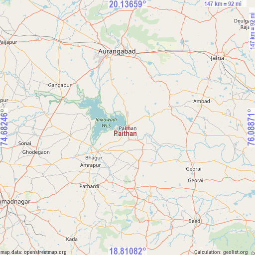
Paithan GPS coordinates[2]
19° 28' 30.216" North, 75° 23' 8.088" East
| Map corner | latitude | longitude |
|---|---|---|
| Upper-left | 20.13659°, | 74.68246° |
| Center: | 19.47506°, | 75.38558° |
| Lower-right: | 18.81082°, | 76.08871° |
| Map W x H: | 147.4×147.4 km | = 91.6×91.6mi |
| max Lat: | 34.9274° ⇑67% North |
| Paithan: | 19.47506° |
| min Lat: | ⇓33% South 8.09008° |
| min Long | Paithan | max Long |
| 68.82655° | 75.38558° | 96.81° |
| W 20.6%⇐ | ⇒79.4% E |
Elevation
Elevation of Paithan is 445 m = 1460 ft, and this is 149.4 m = 490 ft above average elevation for this country.
| Max E: |
3681 m = 12077 ft | 21% |
| Paithan | 445 m 1460 ft | |
| Avg. | 295.6 m = 970 ft | |
Min E: |
1 m = 3 ft | 79% |
See also: India elevation on elevation.city.
Geographical zone
Paithan is located in North Torrid zone (between Equator and Tropic of Cancer). Distance of this Northern Tropic circle is 440.5 km =273.7 mi to North.| Distance of | km | miles | from Paithan |
|---|---|---|---|
| North Pole | 7841.6 | 4872.5 | to North |
| Arctic Circle | 5235.8 | 3253.4 | to North |
| Tropic Cancer | 440.5 | 273.7 | to North |
| Equator | 2165.4 | 1345.5 | to South |


Nearby cities:
15 places around Paithan: (largest is in red/bold)
• Ahmadnagar
80 km =49.7 mi,  238°
238°
• Ambad
45 km =28 mi,  70°
70°
• Aurangabad
45 km =28 mi,  354°
354°
• Beed
66.6 km =41.4 mi,  144°
144°
• Daulatābād
54.1 km =33.6 mi,  341°
341°
• Ellora
65.2 km =40.5 mi, 339°
• Gangāpur
46.4 km =28.8 mi,  302°
302°
• Gevrai
44.9 km =27.9 mi,  121°
121°
• Jālna
66.4 km =41.3 mi,  52°
52°
• Khuldābād
62.5 km =38.8 mi, 341°
• Pāthardi
40.3 km =25 mi,  213°
213°
• Pīpri
38.7 km =24 mi,  23°
23°
• Rāhuri
77.7 km =48.3 mi,  263°
263°
• Vaijāpur
85.3 km =53 mi,  306°
306°
• Ārangaon
86.3 km =53.6 mi,  234°
234°
Sources, notices
• [Note1] Compared only with cities in India existing in our database
• [Src1] Map data: © OpenStreetMap contributors (CC-BY-SA)
• [Src2] Other city data from geonames.org with taken over terms of usage.
• [Src3] Geographical zone / Annual Mean Temperature by Robert A. Rohde @ Wikipedia
