Daulatābād geodata
Daulatābād (Maharashtra) is a populated place; located in India in Asia/Kolkata (GMT+5.5) time zone. With population of 10,000 people, there are 2941 cities with bigger population in this country. Compared to other cities in India, 65.4% of cities are located further ↑North; 80.8% of cities are located further →East and 88.3% of cities have lower elevation than Daulatābād. Note1


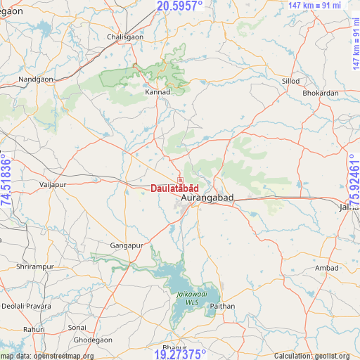
Daulatābād GPS coordinates[2]
19° 56' 9.996" North, 75° 13' 17.328" East
| Map corner | latitude | longitude |
|---|---|---|
| Upper-left | 20.5957°, | 74.51836° |
| Center: | 19.93611°, | 75.22148° |
| Lower-right: | 19.27375°, | 75.92461° |
| Map W x H: | 147×147 km | = 91.3×91.3mi |
| max Lat: | 34.9274° ⇑65.4% North |
| Daulatābād: | 19.93611° |
| min Lat: | ⇓34.6% South 8.09008° |
| min Long | Daulatābād | max Long |
| 68.82655° | 75.22148° | 96.81° |
| W 19.2%⇐ | ⇒80.8% E |
Elevation
Elevation of Daulatābād is 597 m = 1959 ft, and this is 301.4 m = 989 ft above average elevation for this country.
| Max E: |
3681 m = 12077 ft | 11.7% |
| Daulatābād | 597 m 1959 ft | |
| Avg. | 295.6 m = 970 ft | |
Min E: |
1 m = 3 ft | 88.3% |
See also: India elevation on elevation.city.
Geographical zone
Daulatābād is located in North Torrid zone (between Equator and Tropic of Cancer). Distance of this Northern Tropic circle is 389.2 km =241.8 mi to North.| Distance of | km | miles | from Daulatābād |
|---|---|---|---|
| North Pole | 7790.4 | 4840.7 | to North |
| Arctic Circle | 5184.5 | 3221.5 | to North |
| Tropic Cancer | 389.2 | 241.8 | to North |
| Equator | 2216.7 | 1377.4 | to South |


Nearby cities:
15 places around Daulatābād: (largest is in red/bold)
• Ambad
69.4 km =43.1 mi,  121°
121°
• Aurangabad
14.2 km =8.8 mi, 117°
• Chālisgaon
61.8 km =38.4 mi,  339°
339°
• Ellora
11.4 km =7.1 mi,  327°
327°
• Gangāpur
34.5 km =21.4 mi,  219°
219°
• Jālna
70.3 km =43.7 mi,  98°
98°
• Kannad
36.7 km =22.8 mi,  346°
346°
• Khuldābād
8.4 km =5.2 mi, 338°
• Kopargaon
78.2 km =48.6 mi,  265°
265°
• Nāndgaon
72.1 km =44.8 mi,  304°
304°
• Paithan
54.1 km =33.6 mi,  161°
161°
• Pīpri
36.4 km =22.6 mi, 115°
• Sillod
60.8 km =37.8 mi,  47°
47°
• Vaijāpur
51.6 km =32.1 mi, 268°
• Yeola
77.4 km =48.1 mi,  278°
278°
Sources, notices
• [Note1] Compared only with cities in India existing in our database
• [Src1] Map data: © OpenStreetMap contributors (CC-BY-SA)
• [Src2] Other city data from geonames.org with taken over terms of usage.
• [Src3] Geographical zone / Annual Mean Temperature by Robert A. Rohde @ Wikipedia
