Ashti geodata
Ashti (Maharashtra) is a populated place; located in India in Asia/Kolkata (GMT+5.5) time zone. With population of 13,084 people, there are 2647 cities with bigger population in this country. Compared to other cities in India, 67.2% of cities are located further ↑North; 71.3% of cities are located further →East and 78.7% of cities have lower elevation than Ashti. Note1


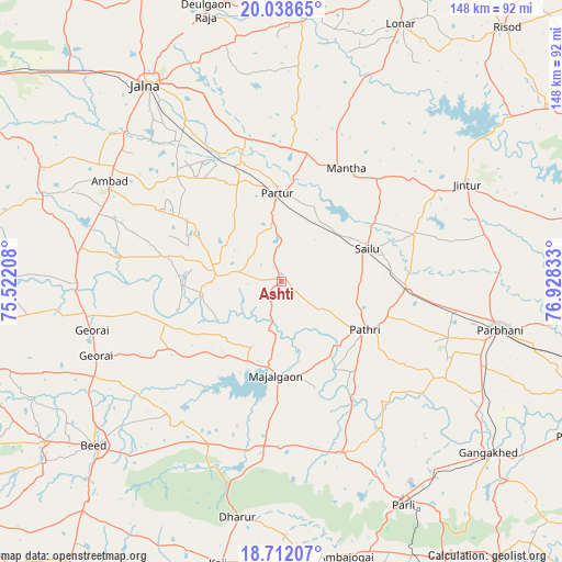
Ashti GPS coordinates[2]
19° 22' 36.156" North, 76° 13' 30.72" East
| Map corner | latitude | longitude |
|---|---|---|
| Upper-left | 20.03865°, | 75.52208° |
| Center: | 19.37671°, | 76.2252° |
| Lower-right: | 18.71207°, | 76.92833° |
| Map W x H: | 147.5×147.5 km | = 91.7×91.7mi |
| max Lat: | 34.9274° ⇑67.2% North |
| Ashti: | 19.37671° |
| min Lat: | ⇓32.8% South 8.09008° |
| min Long | Ashti | max Long |
| 68.82655° | 76.2252° | 96.81° |
| W 28.7%⇐ | ⇒71.3% E |
Elevation
Elevation of Ashti is 441 m = 1447 ft, and this is 145.4 m = 477 ft above average elevation for this country.
| Max E: |
3681 m = 12077 ft | 21.3% |
| Ashti | 441 m 1447 ft | |
| Avg. | 295.6 m = 970 ft | |
Min E: |
1 m = 3 ft | 78.7% |
See also: India elevation on elevation.city.
Geographical zone
Ashti is located in North Torrid zone (between Equator and Tropic of Cancer). Distance of this Northern Tropic circle is 451.4 km =280.5 mi to North.| Distance of | km | miles | from Ashti |
|---|---|---|---|
| North Pole | 7852.6 | 4879.4 | to North |
| Arctic Circle | 5246.7 | 3260.1 | to North |
| Tropic Cancer | 451.4 | 280.5 | to North |
| Equator | 2154.5 | 1338.7 | to South |


Nearby cities:
15 places around Ashti: (largest is in red/bold)
• Ambad
52.7 km =32.7 mi,  299°
299°
• Ambājogāi
73.5 km =45.7 mi,  166°
166°
• Beed
65.4 km =40.6 mi,  228°
228°
• Dhārūr
63.1 km =39.2 mi,  191°
191°
• Gangākher
71.3 km =44.3 mi,  129°
129°
• Gevrai
51.4 km =31.9 mi,  255°
255°
• Jintūr
55.1 km =34.2 mi,  61°
61°
• Jālna
62.6 km =38.9 mi,  325°
325°
• Mājalgaon
24.2 km =15 mi,  184°
184°
• Mānwat
29.8 km =18.5 mi,  106°
106°
• Parbhani
58.5 km =36.4 mi,  101°
101°
• Parli Vaijnāth
66.8 km =41.5 mi,  151°
151°
• Partūr
24.8 km =15.4 mi,  357°
357°
• Pāthri
25.5 km =15.8 mi,  120°
120°
• Selu
24.2 km =15 mi,  68°
68°
Sources, notices
• [Note1] Compared only with cities in India existing in our database
• [Src1] Map data: © OpenStreetMap contributors (CC-BY-SA)
• [Src2] Other city data from geonames.org with taken over terms of usage.
• [Src3] Geographical zone / Annual Mean Temperature by Robert A. Rohde @ Wikipedia
