Deūlgaon Rāja geodata
Deūlgaon Rāja (Maharashtra) is a populated place; located in India in Asia/Kolkata (GMT+5.5) time zone. With population of 26,688 people, there are 1599 cities with bigger population in this country. Compared to other cities in India, 65.1% of cities are located further ↑North; 73.3% of cities are located further →East and 86.5% of cities have lower elevation than Deūlgaon Rāja. Note1


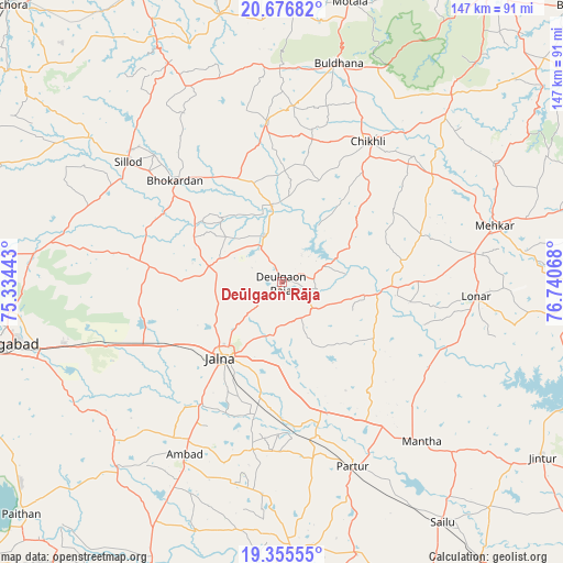
Deūlgaon Rāja GPS coordinates[2]
20° 1' 3.252" North, 76° 2' 15.18" East
| Map corner | latitude | longitude |
|---|---|---|
| Upper-left | 20.67682°, | 75.33443° |
| Center: | 20.01757°, | 76.03755° |
| Lower-right: | 19.35555°, | 76.74068° |
| Map W x H: | 146.9×146.9 km | = 91.3×91.3mi |
| max Lat: | 34.9274° ⇑65.1% North |
| Deūlgaon Rāja: | 20.01757° |
| min Lat: | ⇓34.9% South 8.09008° |
| min Long | Deūlgaon Rāja | max Long |
| 68.82655° | 76.03755° | 96.81° |
| W 26.7%⇐ | ⇒73.3% E |
Elevation
Elevation of Deūlgaon Rāja is 568 m = 1864 ft, and this is 272.4 m = 894 ft above average elevation for this country.
| Max E: |
3681 m = 12077 ft | 13.5% |
| Deūlgaon Rāja | 568 m 1864 ft | |
| Avg. | 295.6 m = 970 ft | |
Min E: |
1 m = 3 ft | 86.5% |
See also: India elevation on elevation.city.
Geographical zone
Deūlgaon Rāja is located in North Torrid zone (between Equator and Tropic of Cancer). Distance of this Northern Tropic circle is 380.2 km =236.2 mi to North.| Distance of | km | miles | from Deūlgaon Rāja |
|---|---|---|---|
| North Pole | 7781.3 | 4835.1 | to North |
| Arctic Circle | 5175.4 | 3215.8 | to North |
| Tropic Cancer | 380.2 | 236.2 | to North |
| Equator | 2225.7 | 1383 | to South |


Nearby cities:
15 places around Deūlgaon Rāja: (largest is in red/bold)
• Ambad
52 km =32.3 mi,  210°
210°
• Ashti
73.9 km =45.9 mi,  164°
164°
• Aurangabad
74.3 km =46.2 mi,  257°
257°
• Buldāna
58.9 km =36.6 mi,  15°
15°
• Chikhli
43.6 km =27.1 mi,  31°
31°
• Jintūr
81.6 km =50.7 mi,  123°
123°
• Jālna
25.2 km =15.7 mi,  218°
218°
• Lonār
50.6 km =31.4 mi,  94°
94°
• Mehekar
57.4 km =35.7 mi,  75°
75°
• Partūr
50.1 km =31.1 mi, 158°
• Pīpri
58.1 km =36.1 mi,  244°
244°
• Risod
78.5 km =48.8 mi, 93°
• Selu
75.4 km =46.9 mi,  145°
145°
• Sillod
51.2 km =31.8 mi,  308°
308°
• Soygaon
77.8 km =48.3 mi,  325°
325°
Sources, notices
• [Note1] Compared only with cities in India existing in our database
• [Src1] Map data: © OpenStreetMap contributors (CC-BY-SA)
• [Src2] Other city data from geonames.org with taken over terms of usage.
• [Src3] Geographical zone / Annual Mean Temperature by Robert A. Rohde @ Wikipedia
