Kunda geodata
Kunda (Uttar Pradesh) is a populated place; located in India in Asia/Kolkata (GMT+5.5) time zone. With population of 24,948 people, there are 1707 cities with bigger population in this country. Compared to other cities in India, 68.5% of cities are located further ↓South; 74.7% of cities are located further ←West and 66.6% of cities have higher elevation than Kunda. Note1


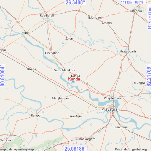
Kunda GPS coordinates[2]
25° 43' 1.272" North, 81° 30' 50.256" East
| Map corner | latitude | longitude |
|---|---|---|
| Upper-left | 26.3488°, | 80.81084° |
| Center: | 25.71702°, | 81.51396° |
| Lower-right: | 25.08186°, | 82.21709° |
| Map W x H: | 140.9×140.9 km | = 87.6×87.6mi |
| max Lat: | 34.9274° ⇑31.5% North |
| Kunda: | 25.71702° |
| min Lat: | ⇓68.5% South 8.09008° |
| min Long | Kunda | max Long |
| 68.82655° | 81.51396° | 96.81° |
| W 74.7%⇐ | ⇒25.3% E |
Elevation
Elevation of Kunda is 109 m = 358 ft, and this is 186.6 m = 612 ft below average elevation for this country.
| Max E: |
3681 m = 12077 ft | 66.6% |
| Avg. | 295.6 m = 970 ft | |
| Kunda | 109 m = 358 ft | |
Min E: |
1 m = 3 ft | 33.4% |
See also: India elevation on elevation.city.
Geographical zone
Kunda is located in North temperate zone (between Tropic of Cancer and the Arctic Circle). Distance of this Northern Tropic circle is 253.5 km =157.5 mi to South.| Distance of | km | miles | from Kunda |
|---|---|---|---|
| North Pole | 7147.6 | 4441.3 | to North |
| Arctic Circle | 4541.7 | 2822.1 | to North |
| Tropic Cancer | 253.5 | 157.5 | to South |
| Equator | 2859.5 | 1776.8 | to South |


Nearby cities:
15 places around Kunda: (largest is in red/bold)
• Allahābād
44.8 km =27.8 mi,  132°
132°
• Bharwāri
17.5 km =10.9 mi,  187°
187°
• Chail
34.4 km =21.4 mi,  159°
159°
• Jhūsi
50.1 km =31.1 mi, 128°
• Karārī
30.7 km =19.1 mi,  196°
196°
• Khāga
41.5 km =25.8 mi,  278°
278°
• Kishanpur
49.9 km =31 mi,  260°
260°
• Lālganj
30.6 km =19 mi,  38°
38°
• Manjhanpur
25 km =15.5 mi,  213°
213°
• Mau Aimma
41.1 km =25.5 mi,  93°
93°
• Parshādepur
39.7 km =24.7 mi,  356°
356°
• Pratāpgarh
47.2 km =29.3 mi,  65°
65°
• Salon
35.2 km =21.9 mi,  350°
350°
• Sarāi Ākil
37.6 km =23.4 mi,  180°
180°
• Sirāthu
21.2 km =13.2 mi,  247°
247°
Sources, notices
• [Note1] Compared only with cities in India existing in our database
• [Src1] Map data: © OpenStreetMap contributors (CC-BY-SA)
• [Src2] Other city data from geonames.org with taken over terms of usage.
• [Src3] Geographical zone / Annual Mean Temperature by Robert A. Rohde @ Wikipedia
