Challakere geodata
Challakere (Karnataka) is a populated place; located in India in Asia/Kolkata (GMT+5.5) time zone. With population of 53,506 people, there are 828 cities with bigger population in this country. Compared to other cities in India, 82.7% of cities are located further ↑North; 66.7% of cities are located further →East and 87.5% of cities have lower elevation than Challakere. Note1


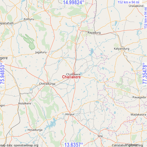
Challakere GPS coordinates[2]
14° 19' 4.8" North, 76° 39' 5.94" East
| Map corner | latitude | longitude |
|---|---|---|
| Upper-left | 14.99824°, | 75.94853° |
| Center: | 14.318°, | 76.65165° |
| Lower-right: | 13.6357°, | 77.35478° |
| Map W x H: | 151.5×151.5 km | = 94.1×94.1mi |
| max Lat: | 34.9274° ⇑82.7% North |
| Challakere: | 14.318° |
| min Lat: | ⇓17.3% South 8.09008° |
| min Long | Challakere | max Long |
| 68.82655° | 76.65165° | 96.81° |
| W 33.3%⇐ | ⇒66.7% E |
Elevation
Elevation of Challakere is 586 m = 1923 ft, and this is 290.4 m = 953 ft above average elevation for this country.
| Max E: |
3681 m = 12077 ft | 12.5% |
| Challakere | 586 m 1923 ft | |
| Avg. | 295.6 m = 970 ft | |
Min E: |
1 m = 3 ft | 87.5% |
See also: Challakere elevation on elevation.city.
Geographical zone
Challakere is located in North Torrid zone (between Equator and Tropic of Cancer). Distance of this Northern Tropic circle is 1013.9 km =630 mi to North.| Distance of | km | miles | from Challakere |
|---|---|---|---|
| North Pole | 8415 | 5228.8 | to North |
| Arctic Circle | 5809.2 | 3609.7 | to North |
| Tropic Cancer | 1013.9 | 630 | to North |
| Equator | 1592 | 989.2 | to South |


Nearby cities:
15 places around Challakere: (largest is in red/bold)
• Channagiri
84.8 km =52.7 mi,  247°
247°
• Chitradurga
29.1 km =18.1 mi, 248°
• Davangere
79.8 km =49.6 mi,  281°
281°
• Hiriyūr
41.7 km =25.9 mi,  185°
185°
• Holalkere
58.9 km =36.6 mi,  238°
238°
• Hosakote
55.9 km =34.7 mi,  94°
94°
• Hosdurga
70.3 km =43.7 mi,  214°
214°
• Jagalūr
40.4 km =25.1 mi,  303°
303°
• Kalyandurg
55 km =34.2 mi,  62°
62°
• Kottūru
73 km =45.4 mi,  320°
320°
• Kūdligi
71.3 km =44.3 mi,  336°
336°
• Māyakonda
61.3 km =38.1 mi,  266°
266°
• Pāvugada
72 km =44.7 mi,  109°
109°
• Rāyadrug
47.6 km =29.6 mi,  26°
26°
• Sīra
69.6 km =43.2 mi,  156°
156°
Sources, notices
• [Note1] Compared only with cities in India existing in our database
• [Src1] Map data: © OpenStreetMap contributors (CC-BY-SA)
• [Src2] Other city data from geonames.org with taken over terms of usage.
• [Src3] Geographical zone / Annual Mean Temperature by Robert A. Rohde @ Wikipedia
