Umarga geodata
Umarga (Maharashtra) is a populated place; located in India in Asia/Kolkata (GMT+5.5) time zone. With population of 32,181 people, there are 1350 cities with bigger population in this country. Compared to other cities in India, 72.1% of cities are located further ↑North; 67% of cities are located further →East and 87.2% of cities have lower elevation than Umarga. Note1


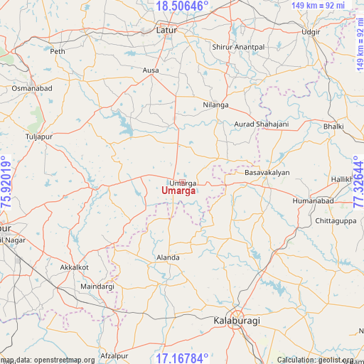
Umarga GPS coordinates[2]
17° 50' 18.276" North, 76° 37' 23.916" East
| Map corner | latitude | longitude |
|---|---|---|
| Upper-left | 18.50646°, | 75.92019° |
| Center: | 17.83841°, | 76.62331° |
| Lower-right: | 17.16784°, | 77.32644° |
| Map W x H: | 148.8×148.8 km | = 92.5×92.5mi |
| max Lat: | 34.9274° ⇑72.1% North |
| Umarga: | 17.83841° |
| min Lat: | ⇓27.9% South 8.09008° |
| min Long | Umarga | max Long |
| 68.82655° | 76.62331° | 96.81° |
| W 33%⇐ | ⇒67% E |
Elevation
Elevation of Umarga is 580 m = 1903 ft, and this is 284.4 m = 933 ft above average elevation for this country.
| Max E: |
3681 m = 12077 ft | 12.8% |
| Umarga | 580 m 1903 ft | |
| Avg. | 295.6 m = 970 ft | |
Min E: |
1 m = 3 ft | 87.2% |
See also: India elevation on elevation.city.
Geographical zone
Umarga is located in North Torrid zone (between Equator and Tropic of Cancer). Distance of this Northern Tropic circle is 622.5 km =386.8 mi to North.| Distance of | km | miles | from Umarga |
|---|---|---|---|
| North Pole | 8023.6 | 4985.6 | to North |
| Arctic Circle | 5417.7 | 3366.4 | to North |
| Tropic Cancer | 622.5 | 386.8 | to North |
| Equator | 1983.4 | 1232.4 | to South |


Nearby cities:
15 places around Umarga: (largest is in red/bold)
• Akalkot
56.3 km =35 mi,  231°
231°
• Aland
31 km =19.3 mi,  190°
190°
• Ausa
47.3 km =29.4 mi,  343°
343°
• Basavakalyān
34.8 km =21.6 mi,  83°
83°
• Bhālki
65.7 km =40.8 mi,  69°
69°
• Dudhani
59.9 km =37.2 mi,  206°
206°
• Gulbarga
60.3 km =37.5 mi,  157°
157°
• Homnābād
53.7 km =33.4 mi,  98°
98°
• Latur
62.4 km =38.8 mi,  354°
354°
• Maindargi
54.9 km =34.1 mi,  219°
219°
• Moram
17.1 km =10.6 mi,  250°
250°
• Naldurg
36.2 km =22.5 mi,  266°
266°
• Nilanga
33.8 km =21 mi,  23°
23°
• Osmanabad
72.6 km =45.1 mi,  301°
301°
• Tuljāpur
61.5 km =38.2 mi,  287°
287°
Sources, notices
• [Note1] Compared only with cities in India existing in our database
• [Src1] Map data: © OpenStreetMap contributors (CC-BY-SA)
• [Src2] Other city data from geonames.org with taken over terms of usage.
• [Src3] Geographical zone / Annual Mean Temperature by Robert A. Rohde @ Wikipedia
