Moram geodata
Moram (Maharashtra) is a populated place; located in India in Asia/Kolkata (GMT+5.5) time zone. With population of 17,696 people, there are 2222 cities with bigger population in this country. Compared to other cities in India, 72.3% of cities are located further ↑North; 68.8% of cities are located further →East and 87.5% of cities have lower elevation than Moram. Note1


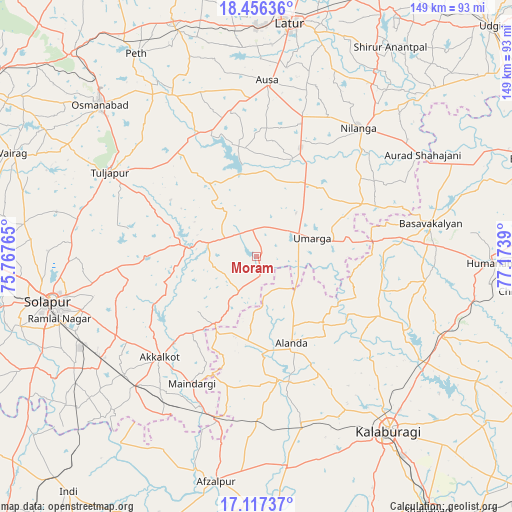
Moram GPS coordinates[2]
17° 47' 17.232" North, 76° 28' 14.772" East
| Map corner | latitude | longitude |
|---|---|---|
| Upper-left | 18.45636°, | 75.76765° |
| Center: | 17.78812°, | 76.47077° |
| Lower-right: | 17.11737°, | 77.1739° |
| Map W x H: | 148.9×148.9 km | = 92.5×92.5mi |
| max Lat: | 34.9274° ⇑72.3% North |
| Moram: | 17.78812° |
| min Lat: | ⇓27.7% South 8.09008° |
| min Long | Moram | max Long |
| 68.82655° | 76.47077° | 96.81° |
| W 31.2%⇐ | ⇒68.8% E |
Elevation
Elevation of Moram is 586 m = 1923 ft, and this is 290.4 m = 953 ft above average elevation for this country.
| Max E: |
3681 m = 12077 ft | 12.5% |
| Moram | 586 m 1923 ft | |
| Avg. | 295.6 m = 970 ft | |
Min E: |
1 m = 3 ft | 87.5% |
See also: India elevation on elevation.city.
Geographical zone
Moram is located in North Torrid zone (between Equator and Tropic of Cancer). Distance of this Northern Tropic circle is 628.1 km =390.3 mi to North.| Distance of | km | miles | from Moram |
|---|---|---|---|
| North Pole | 8029.2 | 4989.1 | to North |
| Arctic Circle | 5423.3 | 3369.9 | to North |
| Tropic Cancer | 628.1 | 390.3 | to North |
| Equator | 1977.9 | 1229 | to South |


Nearby cities:
15 places around Moram: (largest is in red/bold)
• Afzalpur
66.5 km =41.3 mi,  190°
190°
• Akalkot
40.5 km =25.2 mi,  223°
223°
• Aland
27 km =16.8 mi,  157°
157°
• Ausa
51.1 km =31.8 mi,  3°
3°
• Basavakalyān
51.6 km =32.1 mi,  79°
79°
• Dudhani
49.1 km =30.5 mi, 192°
• Gulbarga
63.6 km =39.5 mi,  142°
142°
• Kāti
64.5 km =40.1 mi,  287°
287°
• Maindargi
41.3 km =25.7 mi,  207°
207°
• Naldurg
20.3 km =12.6 mi,  279°
279°
• Nilanga
47.2 km =29.3 mi,  39°
39°
• Osmanabad
63.2 km =39.3 mi,  313°
313°
• Solāpur
60.7 km =37.7 mi,  257°
257°
• Tuljāpur
48.9 km =30.4 mi,  299°
299°
• Umarga
17.1 km =10.6 mi,  70°
70°
Sources, notices
• [Note1] Compared only with cities in India existing in our database
• [Src1] Map data: © OpenStreetMap contributors (CC-BY-SA)
• [Src2] Other city data from geonames.org with taken over terms of usage.
• [Src3] Geographical zone / Annual Mean Temperature by Robert A. Rohde @ Wikipedia
