Sitārganj geodata
Sitārganj (Uttarakhand) is a populated place; located in India in Asia/Kolkata (GMT+5.5) time zone. With population of 24,225 people, there are 1754 cities with bigger population in this country. Compared to other cities in India, 88.9% of cities are located further ↓South; 65.7% of cities are located further ←West and 53.3% of cities have lower elevation than Sitārganj. Note1


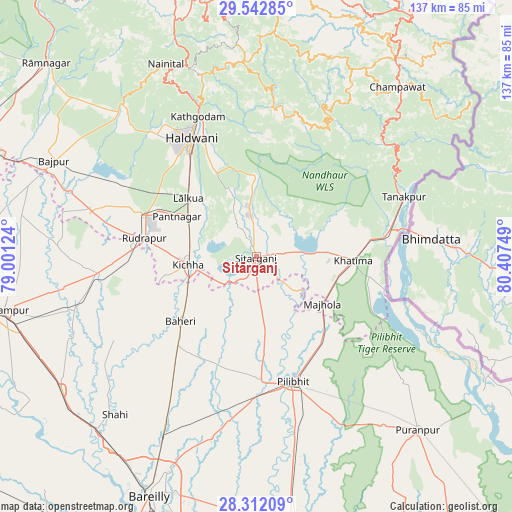
Sitārganj GPS coordinates[2]
28° 55' 45.48" North, 79° 42' 15.696" East
| Map corner | latitude | longitude |
|---|---|---|
| Upper-left | 29.54285°, | 79.00124° |
| Center: | 28.9293°, | 79.70436° |
| Lower-right: | 28.31209°, | 80.40749° |
| Map W x H: | 136.8×136.8 km | = 85×85mi |
| max Lat: | 34.9274° ⇑11.1% North |
| Sitārganj: | 28.9293° |
| min Lat: | ⇓88.9% South 8.09008° |
| min Long | Sitārganj | max Long |
| 68.82655° | 79.70436° | 96.81° |
| W 65.7%⇐ | ⇒34.3% E |
Elevation
Elevation of Sitārganj is 219 m = 719 ft, and this is 76.6 m = 251 ft below average elevation for this country.
| Max E: |
3681 m = 12077 ft | 46.7% |
| Avg. | 295.6 m = 970 ft | |
| Sitārganj | 219 m = 719 ft | |
Min E: |
1 m = 3 ft | 53.3% |
See also: India elevation on elevation.city.
Geographical zone
Sitārganj is located in North temperate zone (between Tropic of Cancer and the Arctic Circle). Distance of this Northern Tropic circle is 610.7 km =379.5 mi to South.| Distance of | km | miles | from Sitārganj |
|---|---|---|---|
| North Pole | 6790.4 | 4219.4 | to North |
| Arctic Circle | 4184.5 | 2600.1 | to North |
| Tropic Cancer | 610.7 | 379.5 | to South |
| Equator | 3216.6 | 1998.7 | to South |


Nearby cities:
15 places around Sitārganj: (largest is in red/bold)
• Baheri
26.5 km =16.5 mi,  229°
229°
• Banbasa
36.8 km =22.9 mi,  79°
79°
• Bhīm Tāl
48.2 km =30 mi,  343°
343°
• Bīlāspur
42.5 km =26.4 mi,  263°
263°
• Deoraniān
40 km =24.9 mi,  213°
213°
• Haldwani
36.8 km =22.9 mi,  332°
332°
• Jahānābād
33.3 km =20.7 mi,  177°
177°
• Khatīma
25.9 km =16.1 mi,  91°
91°
• Kichha
18 km =11.2 mi, 263°
• Nawābganj
43.7 km =27.2 mi,  188°
188°
• Pīlibhīt
34.5 km =21.4 mi,  163°
163°
• Richha
31.5 km =19.6 mi, 214°
• Shergarh
45 km =28 mi, 226°
• Shīshgarh
44 km =27.3 mi,  239°
239°
• Tanakpur
42.7 km =26.5 mi,  67°
67°
Sources, notices
• [Note1] Compared only with cities in India existing in our database
• [Src1] Map data: © OpenStreetMap contributors (CC-BY-SA)
• [Src2] Other city data from geonames.org with taken over terms of usage.
• [Src3] Geographical zone / Annual Mean Temperature by Robert A. Rohde @ Wikipedia
