Shāhpura geodata
Shāhpura (Rajasthan) is a populated place; located in India in Asia/Kolkata (GMT+5.5) time zone. With population of 29,259 people, there are 1482 cities with bigger population in this country. Compared to other cities in India, 67.9% of cities are located further ↓South; 83.4% of cities are located further →East and 73.8% of cities have lower elevation than Shāhpura. Note1


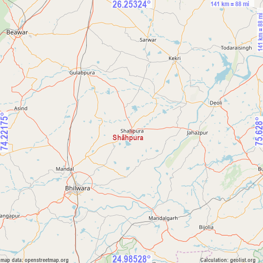
Shāhpura GPS coordinates[2]
25° 37' 15.384" North, 74° 55' 29.532" East
| Map corner | latitude | longitude |
|---|---|---|
| Upper-left | 26.25324°, | 74.22175° |
| Center: | 25.62094°, | 74.92487° |
| Lower-right: | 24.98528°, | 75.628° |
| Map W x H: | 141×141 km | = 87.6×87.6mi |
| max Lat: | 34.9274° ⇑32.1% North |
| Shāhpura: | 25.62094° |
| min Lat: | ⇓67.9% South 8.09008° |
| min Long | Shāhpura | max Long |
| 68.82655° | 74.92487° | 96.81° |
| W 16.6%⇐ | ⇒83.4% E |
Elevation
Elevation of Shāhpura is 371 m = 1217 ft, and this is 75.4 m = 247 ft above average elevation for this country.
| Max E: |
3681 m = 12077 ft | 26.2% |
| Shāhpura | 371 m 1217 ft | |
| Avg. | 295.6 m = 970 ft | |
Min E: |
1 m = 3 ft | 73.8% |
See also: India elevation on elevation.city.
Geographical zone
Shāhpura is located in North temperate zone (between Tropic of Cancer and the Arctic Circle). Distance of this Northern Tropic circle is 242.9 km =150.9 mi to South.| Distance of | km | miles | from Shāhpura |
|---|---|---|---|
| North Pole | 7158.3 | 4448 | to North |
| Arctic Circle | 4552.4 | 2828.7 | to North |
| Tropic Cancer | 242.9 | 150.9 | to South |
| Equator | 2848.8 | 1770.2 | to South |


Nearby cities:
15 places around Shāhpura: (largest is in red/bold)
• Begūn
71.3 km =44.3 mi,  173°
173°
• Bhīlwāra
41.7 km =25.9 mi,  223°
223°
• Borkhera
72.6 km =45.1 mi,  98°
98°
• Būndi
74.3 km =46.2 mi,  105°
105°
• Deoli
48 km =29.8 mi,  71°
71°
• Gulābpura
41.2 km =25.6 mi,  319°
319°
• Jahāzpur
35.2 km =21.9 mi,  90°
90°
• Kekri
45 km =28 mi,  30°
30°
• Māndal
40.8 km =25.4 mi,  240°
240°
• Māndalgarh
49.7 km =30.9 mi,  162°
162°
• Nasīrābād
78.4 km =48.7 mi,  345°
345°
• Sarwār
49.9 km =31 mi,  9°
9°
• Todaraisingh
71.5 km =44.4 mi,  51°
51°
• Uniāra
65.9 km =40.9 mi, 26°
• Āsind
60.7 km =37.7 mi,  281°
281°
Sources, notices
• [Note1] Compared only with cities in India existing in our database
• [Src1] Map data: © OpenStreetMap contributors (CC-BY-SA)
• [Src2] Other city data from geonames.org with taken over terms of usage.
• [Src3] Geographical zone / Annual Mean Temperature by Robert A. Rohde @ Wikipedia
