Āsind geodata
Āsind (Rajasthan) is a populated place; located in India in Asia/Kolkata (GMT+5.5) time zone. With population of 15,389 people, there are 2425 cities with bigger population in this country. Compared to other cities in India, 68.6% of cities are located further ↓South; 87.7% of cities are located further →East and 81.4% of cities have lower elevation than Āsind. Note1


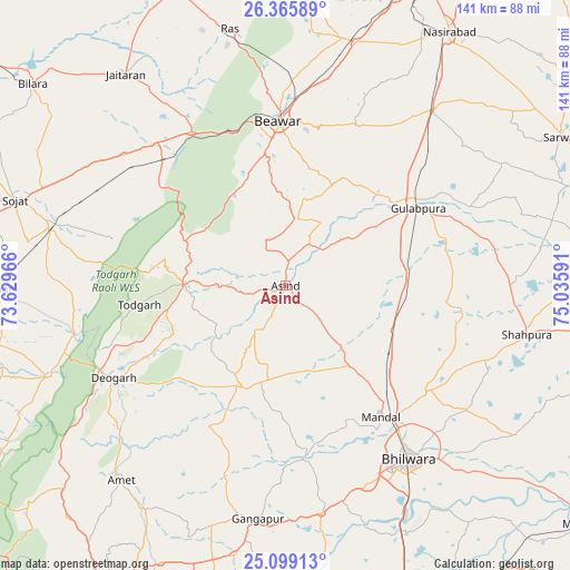
Āsind GPS coordinates[2]
25° 44' 3.12" North, 74° 19' 58.008" East
| Map corner | latitude | longitude |
|---|---|---|
| Upper-left | 26.36589°, | 73.62966° |
| Center: | 25.7342°, | 74.33278° |
| Lower-right: | 25.09913°, | 75.03591° |
| Map W x H: | 140.9×140.9 km | = 87.6×87.6mi |
| max Lat: | 34.9274° ⇑31.4% North |
| Āsind: | 25.7342° |
| min Lat: | ⇓68.6% South 8.09008° |
| min Long | Āsind | max Long |
| 68.82655° | 74.33278° | 96.81° |
| W 12.3%⇐ | ⇒87.7% E |
Elevation
Elevation of Āsind is 478 m = 1568 ft, and this is 182.4 m = 598 ft above average elevation for this country.
| Max E: |
3681 m = 12077 ft | 18.6% |
| Āsind | 478 m 1568 ft | |
| Avg. | 295.6 m = 970 ft | |
Min E: |
1 m = 3 ft | 81.4% |
See also: India elevation on elevation.city.
Geographical zone
Āsind is located in North temperate zone (between Tropic of Cancer and the Arctic Circle). Distance of this Northern Tropic circle is 255.5 km =158.8 mi to South.| Distance of | km | miles | from Āsind |
|---|---|---|---|
| North Pole | 7145.7 | 4440.1 | to North |
| Arctic Circle | 4539.8 | 2820.9 | to North |
| Tropic Cancer | 255.5 | 158.8 | to South |
| Equator | 2861.4 | 1778 | to South |


Nearby cities:
15 places around Āsind: (largest is in red/bold)
• Amet
62.7 km =39 mi,  220°
220°
• Beāwar
40.8 km =25.4 mi,  358°
358°
• Bhīlwāra
53 km =32.9 mi,  144°
144°
• Bilāra
80 km =49.7 mi,  308°
308°
• Devgarh
48.5 km =30.1 mi,  241°
241°
• Gangāpur
57.7 km =35.9 mi,  187°
187°
• Gulābpura
37.9 km =23.5 mi,  59°
59°
• Jaitāran
65.6 km =40.8 mi,  322°
322°
• Māndal
40.3 km =25 mi, 143°
• Nasīrābād
75 km =46.6 mi,  32°
32°
• Nīmāj
56.9 km =35.4 mi, 324°
• Raipur
46.2 km =28.7 mi, 317°
• Sarwār
77.1 km =47.9 mi, 61°
• Shāhpura
60.7 km =37.7 mi,  101°
101°
• Sojat
70 km =43.5 mi,  287°
287°
Sources, notices
• [Note1] Compared only with cities in India existing in our database
• [Src1] Map data: © OpenStreetMap contributors (CC-BY-SA)
• [Src2] Other city data from geonames.org with taken over terms of usage.
• [Src3] Geographical zone / Annual Mean Temperature by Robert A. Rohde @ Wikipedia
