Gondiā geodata
Gondiā (Maharashtra) is a populated place; located in India in Asia/Kolkata (GMT+5.5) time zone. With population of 124,897 people, there are 351 cities with bigger population in this country. Compared to other cities in India, 59.3% of cities are located further ↑North; 69.5% of cities are located further ←West and 69.5% of cities have lower elevation than Gondiā. Note1


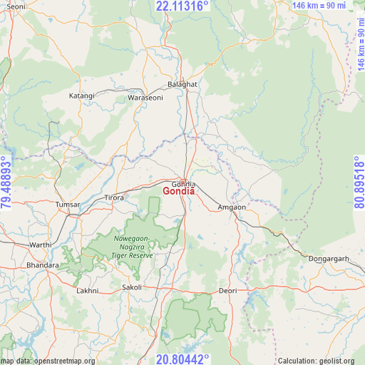
Gondiā GPS coordinates[2]
21° 27' 36.936" North, 80° 11' 31.38" East
| Map corner | latitude | longitude |
|---|---|---|
| Upper-left | 22.11316°, | 79.48893° |
| Center: | 21.46026°, | 80.19205° |
| Lower-right: | 20.80442°, | 80.89518° |
| Map W x H: | 145.5×145.5 km | = 90.4×90.4mi |
| max Lat: | 34.9274° ⇑59.3% North |
| Gondiā: | 21.46026° |
| min Lat: | ⇓40.7% South 8.09008° |
| min Long | Gondiā | max Long |
| 68.82655° | 80.19205° | 96.81° |
| W 69.5%⇐ | ⇒30.5% E |
Elevation
Elevation of Gondiā is 322 m = 1056 ft, and this is 26.4 m = 87 ft above average elevation for this country.
| Max E: |
3681 m = 12077 ft | 30.5% |
| Gondiā | 322 m 1056 ft | |
| Avg. | 295.6 m = 970 ft | |
Min E: |
1 m = 3 ft | 69.5% |
See also: Gondiā elevation on elevation.city.
Geographical zone
Gondiā is located in North Torrid zone (between Equator and Tropic of Cancer). Distance of this Northern Tropic circle is 219.8 km =136.6 mi to North.| Distance of | km | miles | from Gondiā |
|---|---|---|---|
| North Pole | 7620.9 | 4735.4 | to North |
| Arctic Circle | 5015 | 3116.2 | to North |
| Tropic Cancer | 219.8 | 136.6 | to North |
| Equator | 2386.2 | 1482.7 | to South |


Nearby cities:
15 places around Gondiā: (largest is in red/bold)
• Baihar
80.3 km =49.9 mi,  27°
27°
• Barghāt
79.2 km =49.2 mi,  323°
323°
• Bhandāra
65 km =40.4 mi,  240°
240°
• Bhānpurī
86.9 km =54 mi,  118°
118°
• Bālāghāt
39.5 km =24.5 mi,  359°
359°
• Chhuīkhadān
83.7 km =52 mi,  85°
85°
• Chicholi
50.8 km =31.6 mi,  271°
271°
• Dongargarh
65.6 km =40.8 mi, 117°
• Hīrāpur Hamesha
43.3 km =26.9 mi,  284°
284°
• Katangi
53 km =32.9 mi,  311°
311°
• Khairāgarh
81.6 km =50.7 mi, 93°
• Tirodi
54.9 km =34.1 mi,  297°
297°
• Tumsar
48.2 km =30 mi,  259°
259°
• Ukwā
63.5 km =39.5 mi, 26°
• Wārāseonī
36.9 km =22.9 mi,  335°
335°
Sources, notices
• [Note1] Compared only with cities in India existing in our database
• [Src1] Map data: © OpenStreetMap contributors (CC-BY-SA)
• [Src2] Other city data from geonames.org with taken over terms of usage.
• [Src3] Geographical zone / Annual Mean Temperature by Robert A. Rohde @ Wikipedia
