Ghugus geodata
Ghugus (Maharashtra) is a populated place; located in India in Asia/Kolkata (GMT+5.5) time zone. With population of 31,859 people, there are 1366 cities with bigger population in this country. Compared to other cities in India, 65.4% of cities are located further ↑North; 60% of cities are located further ←West and 50.5% of cities have higher elevation than Ghugus. Note1


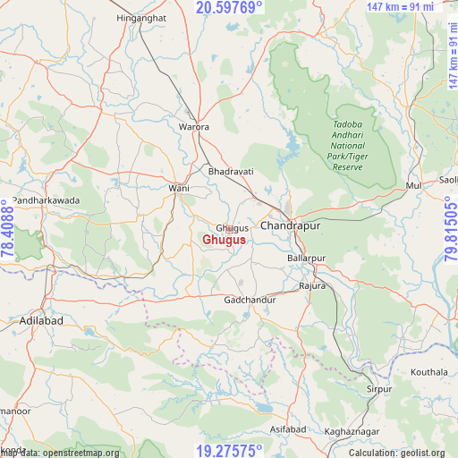
Ghugus GPS coordinates[2]
19° 56' 17.16" North, 79° 6' 42.912" East
| Map corner | latitude | longitude |
|---|---|---|
| Upper-left | 20.59769°, | 78.4088° |
| Center: | 19.9381°, | 79.11192° |
| Lower-right: | 19.27575°, | 79.81505° |
| Map W x H: | 147×147 km | = 91.3×91.3mi |
| max Lat: | 34.9274° ⇑65.4% North |
| Ghugus: | 19.9381° |
| min Lat: | ⇓34.6% South 8.09008° |
| min Long | Ghugus | max Long |
| 68.82655° | 79.11192° | 96.81° |
| W 60%⇐ | ⇒40% E |
Elevation
Elevation of Ghugus is 199 m = 653 ft, and this is 96.6 m = 317 ft below average elevation for this country.
| Max E: |
3681 m = 12077 ft | 50.5% |
| Avg. | 295.6 m = 970 ft | |
| Ghugus | 199 m = 653 ft | |
Min E: |
1 m = 3 ft | 49.5% |
See also: India elevation on elevation.city.
Geographical zone
Ghugus is located in North Torrid zone (between Equator and Tropic of Cancer). Distance of this Northern Tropic circle is 389 km =241.7 mi to North.| Distance of | km | miles | from Ghugus |
|---|---|---|---|
| North Pole | 7790.2 | 4840.6 | to North |
| Arctic Circle | 5184.3 | 3221.4 | to North |
| Tropic Cancer | 389 | 241.7 | to North |
| Equator | 2216.9 | 1377.5 | to South |


Nearby cities:
15 places around Ghugus: (largest is in red/bold)
• Asifābād
66.9 km =41.6 mi,  164°
164°
• Ballālpur
26.5 km =16.5 mi,  112°
112°
• Chānda
19.2 km =11.9 mi,  85°
85°
• Chāndur
23.5 km =14.6 mi, 164°
• Dasnapur
70.3 km =43.7 mi,  243°
243°
• Durgāpur
21.3 km =13.2 mi,  69°
69°
• Hinganghāt
73.6 km =45.7 mi,  337°
337°
• Kyathampalle
68 km =42.3 mi, 243°
• Mūl
61 km =37.9 mi,  76°
76°
• Rājur
29.9 km =18.6 mi,  310°
310°
• Rājūra
31.8 km =19.8 mi,  123°
123°
• Sirpur
70.4 km =43.7 mi,  136°
136°
• Wani
21.1 km =13.1 mi, 308°
• Warora
34.3 km =21.3 mi, 340°
• Ādilābād
67.1 km =41.7 mi, 243°
Sources, notices
• [Note1] Compared only with cities in India existing in our database
• [Src1] Map data: © OpenStreetMap contributors (CC-BY-SA)
• [Src2] Other city data from geonames.org with taken over terms of usage.
• [Src3] Geographical zone / Annual Mean Temperature by Robert A. Rohde @ Wikipedia
