Durgāpur geodata
Durgāpur (Maharashtra) is a populated place; located in India in Asia/Kolkata (GMT+5.5) time zone. With population of 18,561 people, there are 2161 cities with bigger population in this country. Compared to other cities in India, 65.2% of cities are located further ↑North; 61.8% of cities are located further ←West and 50.5% of cities have lower elevation than Durgāpur. Note1


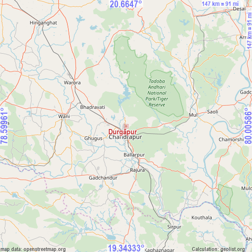
Durgāpur GPS coordinates[2]
20° 0' 19.44" North, 79° 18' 9.828" East
| Map corner | latitude | longitude |
|---|---|---|
| Upper-left | 20.6647°, | 78.59961° |
| Center: | 20.0054°, | 79.30273° |
| Lower-right: | 19.34333°, | 80.00586° |
| Map W x H: | 146.9×146.9 km | = 91.3×91.3mi |
| max Lat: | 34.9274° ⇑65.2% North |
| Durgāpur: | 20.0054° |
| min Lat: | ⇓34.8% South 8.09008° |
| min Long | Durgāpur | max Long |
| 68.82655° | 79.30273° | 96.81° |
| W 61.8%⇐ | ⇒38.2% E |
Elevation
Elevation of Durgāpur is 205 m = 673 ft, and this is 90.6 m = 297 ft below average elevation for this country.
| Max E: |
3681 m = 12077 ft | 49.5% |
| Avg. | 295.6 m = 970 ft | |
| Durgāpur | 205 m = 673 ft | |
Min E: |
1 m = 3 ft | 50.5% |
See also: India elevation on elevation.city.
Geographical zone
Durgāpur is located in North Torrid zone (between Equator and Tropic of Cancer). Distance of this Northern Tropic circle is 381.5 km =237.1 mi to North.| Distance of | km | miles | from Durgāpur |
|---|---|---|---|
| North Pole | 7782.7 | 4835.9 | to North |
| Arctic Circle | 5176.8 | 3216.7 | to North |
| Tropic Cancer | 381.5 | 237.1 | to North |
| Equator | 2224.4 | 1382.2 | to South |


Nearby cities:
15 places around Durgāpur: (largest is in red/bold)
• Asifābād
72 km =44.7 mi,  181°
181°
• Ballālpur
18.2 km =11.3 mi,  165°
165°
• Chānda
6.1 km =3.8 mi,  187°
187°
• Chāndur
33.1 km =20.6 mi,  204°
204°
• Ghugus
21.3 km =13.2 mi,  249°
249°
• Hinganghāt
77.3 km =48 mi,  321°
321°
• Kagaznāgār
76.8 km =47.7 mi, 167°
• Kothāpet
75.1 km =46.7 mi, 165°
• Mūl
39.9 km =24.8 mi,  79°
79°
• Rājur
44.4 km =27.6 mi,  285°
285°
• Rājūra
25.9 km =16.1 mi, 165°
• Sirpur
65.1 km =40.5 mi,  153°
153°
• Wani
36.9 km =22.9 mi,  278°
278°
• Warora
40 km =24.9 mi,  308°
308°
• Ādilābād
88.4 km =54.9 mi, 245°
Sources, notices
• [Note1] Compared only with cities in India existing in our database
• [Src1] Map data: © OpenStreetMap contributors (CC-BY-SA)
• [Src2] Other city data from geonames.org with taken over terms of usage.
• [Src3] Geographical zone / Annual Mean Temperature by Robert A. Rohde @ Wikipedia
