Jogbani geodata
Jogbani (Bihar) is a populated place; located in India in Asia/Kolkata (GMT+5.5) time zone. With population of 33,300 people, there are 1307 cities with bigger population in this country. Compared to other cities in India, 73.8% of cities are located further ↓South; 89.8% of cities are located further ←West and 75% of cities have higher elevation than Jogbani. Note1


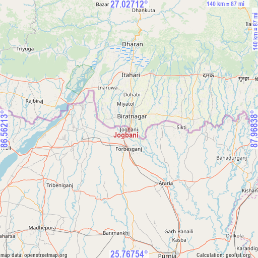
Jogbani GPS coordinates[2]
26° 23' 56.58" North, 87° 15' 54.9" East
| Map corner | latitude | longitude |
|---|---|---|
| Upper-left | 27.02712°, | 86.56213° |
| Center: | 26.39905°, | 87.26525° |
| Lower-right: | 25.76754°, | 87.96838° |
| Map W x H: | 140.1×140.1 km | = 87.1×87.1mi |
| max Lat: | 34.9274° ⇑26.2% North |
| Jogbani: | 26.39905° |
| min Lat: | ⇓73.8% South 8.09008° |
| min Long | Jogbani | max Long |
| 68.82655° | 87.26525° | 96.81° |
| W 89.8%⇐ | ⇒10.2% E |
Elevation
Elevation of Jogbani is 68 m = 223 ft, and this is 227.6 m = 747 ft below average elevation for this country.
| Max E: |
3681 m = 12077 ft | 75% |
| Avg. | 295.6 m = 970 ft | |
| Jogbani | 68 m = 223 ft | |
Min E: |
1 m = 3 ft | 25% |
See also: India elevation on elevation.city.
Geographical zone
Jogbani is located in North temperate zone (between Tropic of Cancer and the Arctic Circle). Distance of this Northern Tropic circle is 329.4 km =204.7 mi to South.| Distance of | km | miles | from Jogbani |
|---|---|---|---|
| North Pole | 7071.8 | 4394.2 | to North |
| Arctic Circle | 4465.9 | 2775 | to North |
| Tropic Cancer | 329.4 | 204.7 | to South |
| Equator | 2935.3 | 1823.9 | to South |


Nearby cities:
15 places around Jogbani: (largest is in red/bold)
• Arāria
37.2 km =23.1 mi,  138°
138°
• Bahādurganj
57.8 km =35.9 mi,  105°
105°
• Banmankhi
57.2 km =35.5 mi,  187°
187°
• Bhawanipur
24.4 km =15.2 mi,  284°
284°
• Bīrpur
28 km =17.4 mi,  295°
295°
• Chhātāpur
32.7 km =20.3 mi,  232°
232°
• Forbesganj
10.7 km =6.6 mi,  179°
179°
• Kasba
66.2 km =41.1 mi,  155°
155°
• Kishanganj
76.3 km =47.4 mi,  115°
115°
• Madhipura
71 km =44.1 mi,  221°
221°
• Murlīganj
62 km =38.5 mi,  205°
205°
• Nirmāli
68.4 km =42.5 mi,  262°
262°
• Purnia
72 km =44.7 mi, 163°
• Shahbazpur
10.7 km =6.6 mi,  167°
167°
• Supaul
73.9 km =45.9 mi,  244°
244°
Sources, notices
• [Note1] Compared only with cities in India existing in our database
• [Src1] Map data: © OpenStreetMap contributors (CC-BY-SA)
• [Src2] Other city data from geonames.org with taken over terms of usage.
• [Src3] Geographical zone / Annual Mean Temperature by Robert A. Rohde @ Wikipedia
