Aizawl geodata
Aizawl (Mizoram) is a seat of a first-order administrative division; located in India in Asia/Kolkata (GMT+5.5) time zone. With population of 265,331 people, there are 159 cities with bigger population in this country. Compared to other cities in India, 56.3% of cities are located further ↓South; 97.5% of cities are located further ←West and 96.5% of cities have lower elevation than Aizawl. Note1


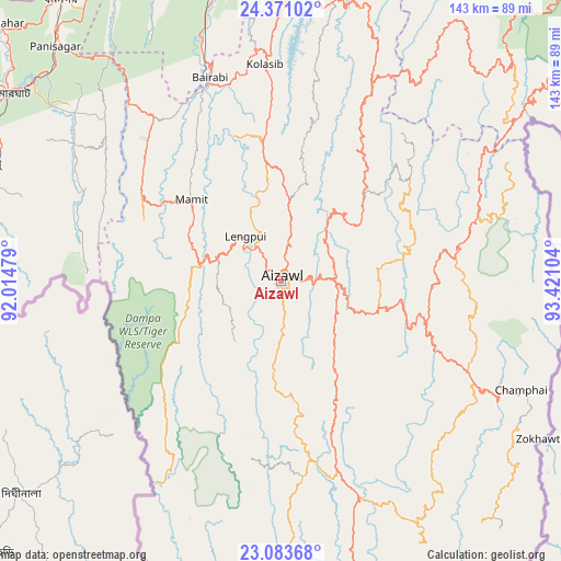
Aizawl GPS coordinates[2]
23° 43' 44.184" North, 92° 43' 4.476" East
| Map corner | latitude | longitude |
|---|---|---|
| Upper-left | 24.37102°, | 92.01479° |
| Center: | 23.72894°, | 92.71791° |
| Lower-right: | 23.08368°, | 93.42104° |
| Map W x H: | 143.1×143.1 km | = 88.9×88.9mi |
| max Lat: | 34.9274° ⇑43.7% North |
| Aizawl: | 23.72894° |
| min Lat: | ⇓56.3% South 8.09008° |
| min Long | Aizawl | max Long |
| 68.82655° | 92.71791° | 96.81° |
| W 97.5%⇐ | ⇒2.5% E |
Elevation
Elevation of Aizawl is 1080 m = 3543 ft, and this is 784.4 m = 2573 ft above average elevation for this country.
| Max E: |
3681 m = 12077 ft | 3.5% |
| Aizawl | 1080 m 3543 ft | |
| Avg. | 295.6 m = 970 ft | |
Min E: |
1 m = 3 ft | 96.5% |
See also: Aizawl elevation on elevation.city.
Geographical zone
Aizawl is located in North temperate zone (between Tropic of Cancer and the Arctic Circle). Distance of this Northern Tropic circle is 32.5 km =20.2 mi to South.| Distance of | km | miles | from Aizawl |
|---|---|---|---|
| North Pole | 7368.7 | 4578.7 | to North |
| Arctic Circle | 4762.8 | 2959.5 | to North |
| Tropic Cancer | 32.5 | 20.2 | to South |
| Equator | 2638.4 | 1639.4 | to South |


Nearby cities:
15 places around Aizawl: (largest is in red/bold)
• Darlawn
38 km =23.6 mi,  33°
33°
• Dharmanagar
90.3 km =56.1 mi,  321°
321°
• Kailāshahar
98.8 km =61.4 mi,  312°
312°
• Khawhai
57.2 km =35.5 mi,  133°
133°
• Kolasib
55.2 km =34.3 mi,  355°
355°
• Lunglei
93 km =57.8 mi,  178°
178°
• Lāla
92.3 km =57.4 mi,  353°
353°
• Mamit
32 km =19.9 mi, 313°
• North Vanlaiphai
75.2 km =46.7 mi,  151°
151°
• Pherzawl
76.2 km =47.3 mi,  38°
38°
• Sairang
11.2 km =7 mi, 323°
• Serchhīp
50.2 km =31.2 mi,  164°
164°
• Sāitlaw
30.7 km =19.1 mi,  331°
331°
• Thenzawl
46 km =28.6 mi, 175°
• Āmbāsa
90.8 km =56.4 mi,  284°
284°
Sources, notices
• [Note1] Compared only with cities in India existing in our database
• [Src1] Map data: © OpenStreetMap contributors (CC-BY-SA)
• [Src2] Other city data from geonames.org with taken over terms of usage.
• [Src3] Geographical zone / Annual Mean Temperature by Robert A. Rohde @ Wikipedia
