Garhmuktesar geodata
Garhmuktesar (Uttar Pradesh) is a populated place; located in India in Asia/Kolkata (GMT+5.5) time zone. With population of 37,043 people, there are 1184 cities with bigger population in this country. Compared to other cities in India, 88.2% of cities are located further ↓South; 50.1% of cities are located further →East and 52.5% of cities have lower elevation than Garhmuktesar. Note1


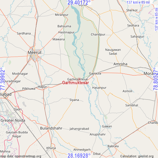
Garhmuktesar GPS coordinates[2]
28° 47' 14.352" North, 78° 6' 7.704" East
| Map corner | latitude | longitude |
|---|---|---|
| Upper-left | 29.40172°, | 77.39902° |
| Center: | 28.78732°, | 78.10214° |
| Lower-right: | 28.16928°, | 78.80527° |
| Map W x H: | 137×137 km | = 85.1×85.1mi |
| max Lat: | 34.9274° ⇑11.8% North |
| Garhmuktesar: | 28.78732° |
| min Lat: | ⇓88.2% South 8.09008° |
| min Long | Garhmuktesar | max Long |
| 68.82655° | 78.10214° | 96.81° |
| W 49.9%⇐ | ⇒50.1% E |
Elevation
Elevation of Garhmuktesar is 215 m = 705 ft, and this is 80.6 m = 264 ft below average elevation for this country.
| Max E: |
3681 m = 12077 ft | 47.5% |
| Avg. | 295.6 m = 970 ft | |
| Garhmuktesar | 215 m = 705 ft | |
Min E: |
1 m = 3 ft | 52.5% |
See also: India elevation on elevation.city.
Geographical zone
Garhmuktesar is located in North temperate zone (between Tropic of Cancer and the Arctic Circle). Distance of this Northern Tropic circle is 594.9 km =369.7 mi to South.| Distance of | km | miles | from Garhmuktesar |
|---|---|---|---|
| North Pole | 6806.2 | 4229.2 | to North |
| Arctic Circle | 4200.3 | 2609.9 | to North |
| Tropic Cancer | 594.9 | 369.7 | to South |
| Equator | 3200.8 | 1988.9 | to South |


Nearby cities:
15 places around Garhmuktesar: (largest is in red/bold)
• Amroha
38.1 km =23.7 mi,  70°
70°
• Babugarh
25.9 km =16.1 mi,  254°
254°
• Bachhraon
20.2 km =12.6 mi,  39°
39°
• Chāndpur
42 km =26.1 mi,  23°
23°
• Dhanaura
24.3 km =15.1 mi, 38°
• Gajraula
14.9 km =9.3 mi,  64°
64°
• Gulāothi
37.3 km =23.2 mi,  233°
233°
• Hasanpur
19.2 km =11.9 mi,  112°
112°
• Hāpur
32 km =19.9 mi,  258°
258°
• Kharkhauda
35.5 km =22.1 mi,  278°
278°
• Khānpur
28.3 km =17.6 mi,  187°
187°
• Kithor
18.2 km =11.3 mi,  299°
299°
• Mawāna
39.2 km =24.4 mi,  333°
333°
• Parīchhatgarh
26.8 km =16.7 mi,  322°
322°
• Saidpur
27.2 km =16.9 mi,  223°
223°
Sources, notices
• [Note1] Compared only with cities in India existing in our database
• [Src1] Map data: © OpenStreetMap contributors (CC-BY-SA)
• [Src2] Other city data from geonames.org with taken over terms of usage.
• [Src3] Geographical zone / Annual Mean Temperature by Robert A. Rohde @ Wikipedia
