Amet geodata
Amet (Rajasthan) is a populated place; located in India in Asia/Kolkata (GMT+5.5) time zone. With population of 17,434 people, there are 2245 cities with bigger population in this country. Compared to other cities in India, 65.2% of cities are located further ↓South; 90.1% of cities are located further →East and 87.3% of cities have lower elevation than Amet. Note1


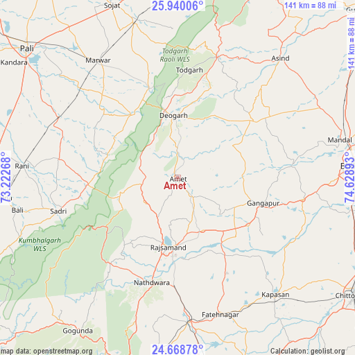
Amet GPS coordinates[2]
25° 18' 21.924" North, 73° 55' 32.88" East
| Map corner | latitude | longitude |
|---|---|---|
| Upper-left | 25.94006°, | 73.22268° |
| Center: | 25.30609°, | 73.9258° |
| Lower-right: | 24.66878°, | 74.62893° |
| Map W x H: | 141.4×141.4 km | = 87.9×87.9mi |
| max Lat: | 34.9274° ⇑34.8% North |
| Amet: | 25.30609° |
| min Lat: | ⇓65.2% South 8.09008° |
| min Long | Amet | max Long |
| 68.82655° | 73.9258° | 96.81° |
| W 9.9%⇐ | ⇒90.1% E |
Elevation
Elevation of Amet is 584 m = 1916 ft, and this is 288.4 m = 946 ft above average elevation for this country.
| Max E: |
3681 m = 12077 ft | 12.7% |
| Amet | 584 m 1916 ft | |
| Avg. | 295.6 m = 970 ft | |
Min E: |
1 m = 3 ft | 87.3% |
See also: India elevation on elevation.city.
Geographical zone
Amet is located in North temperate zone (between Tropic of Cancer and the Arctic Circle). Distance of this Northern Tropic circle is 207.9 km =129.2 mi to South.| Distance of | km | miles | from Amet |
|---|---|---|---|
| North Pole | 7193.3 | 4469.7 | to North |
| Arctic Circle | 4587.4 | 2850.5 | to North |
| Tropic Cancer | 207.9 | 129.2 | to South |
| Equator | 2813.8 | 1748.4 | to South |


Nearby cities:
15 places around Amet: (largest is in red/bold)
• Bhīlwāra
72 km =44.7 mi,  86°
86°
• Bāli
65 km =40.4 mi,  259°
259°
• Dariba
44.9 km =27.9 mi,  152°
152°
• Devgarh
24.4 km =15.2 mi,  355°
355°
• Gangāpur
35 km =21.7 mi,  105°
105°
• Māndal
66.4 km =41.3 mi,  76°
76°
• Nāthdwāra
42.2 km =26.2 mi,  194°
194°
• Pāli
79.7 km =49.5 mi,  310°
310°
• Raipur
82.5 km =51.3 mi,  6°
6°
• Rājsamand
26.5 km =16.5 mi, 190°
• Rāni
62.2 km =38.6 mi,  274°
274°
• Sojat
73.6 km =45.7 mi,  339°
339°
• Sādri
49.4 km =30.7 mi,  254°
254°
• Udaipur
82.9 km =51.5 mi, 194°
• Āsind
62.7 km =39 mi,  40°
40°
Sources, notices
• [Note1] Compared only with cities in India existing in our database
• [Src1] Map data: © OpenStreetMap contributors (CC-BY-SA)
• [Src2] Other city data from geonames.org with taken over terms of usage.
• [Src3] Geographical zone / Annual Mean Temperature by Robert A. Rohde @ Wikipedia
