Udaipur geodata
Udaipur (Rajasthan) is a populated place; located in India in Asia/Kolkata (GMT+5.5) time zone. With population of 422,784 people, there are 108 cities with bigger population in this country. Compared to other cities in India, 61.1% of cities are located further ↓South; 91.7% of cities are located further →East and 86.2% of cities have lower elevation than Udaipur. Note1


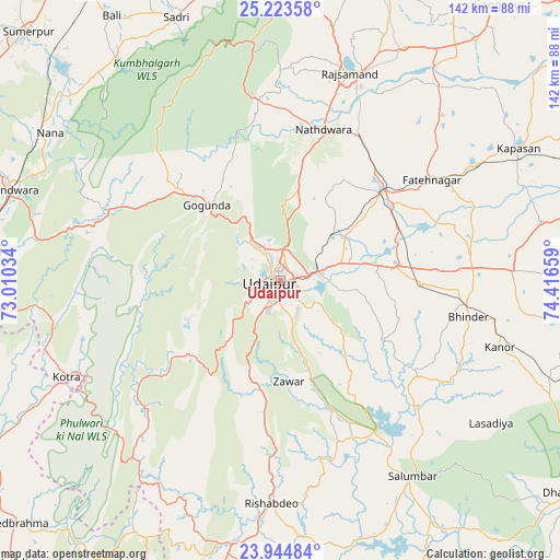
Udaipur GPS coordinates[2]
24° 35' 9.024" North, 73° 42' 48.456" East
| Map corner | latitude | longitude |
|---|---|---|
| Upper-left | 25.22358°, | 73.01034° |
| Center: | 24.58584°, | 73.71346° |
| Lower-right: | 23.94484°, | 74.41659° |
| Map W x H: | 142.2×142.2 km | = 88.4×88.4mi |
| max Lat: | 34.9274° ⇑38.9% North |
| Udaipur: | 24.58584° |
| min Lat: | ⇓61.1% South 8.09008° |
| min Long | Udaipur | max Long |
| 68.82655° | 73.71346° | 96.81° |
| W 8.3%⇐ | ⇒91.7% E |
Elevation
Elevation of Udaipur is 565 m = 1854 ft, and this is 269.4 m = 884 ft above average elevation for this country.
| Max E: |
3681 m = 12077 ft | 13.8% |
| Udaipur | 565 m 1854 ft | |
| Avg. | 295.6 m = 970 ft | |
Min E: |
1 m = 3 ft | 86.2% |
See also: Udaipur elevation on elevation.city.
Geographical zone
Udaipur is located in North temperate zone (between Tropic of Cancer and the Arctic Circle). Distance of this Northern Tropic circle is 127.8 km =79.4 mi to South.| Distance of | km | miles | from Udaipur |
|---|---|---|---|
| North Pole | 7273.4 | 4519.5 | to North |
| Arctic Circle | 4667.5 | 2900.2 | to North |
| Tropic Cancer | 127.8 | 79.4 | to South |
| Equator | 2733.7 | 1698.6 | to South |


Nearby cities:
15 places around Udaipur: (largest is in red/bold)
• Amet
82.9 km =51.5 mi,  14°
14°
• Bari Sādri
79.2 km =49.2 mi,  104°
104°
• Bhindār
48.6 km =30.2 mi, 101°
• Bāli
80.2 km =49.8 mi,  327°
327°
• Dariba
58.6 km =36.4 mi,  46°
46°
• Dūngarpur
82.6 km =51.3 mi,  179°
179°
• Gangāpur
89.5 km =55.6 mi,  38°
38°
• Khedbrahma
91.6 km =56.9 mi,  227°
227°
• Kānor
58.3 km =36.2 mi,  106°
106°
• Nāthdwāra
40.7 km =25.3 mi,  15°
15°
• Pindwāra
70.6 km =43.9 mi,  289°
289°
• Rājsamand
56.5 km =35.1 mi, 17°
• Sheoganj
89.6 km =55.7 mi,  313°
313°
• Sādri
71.7 km =44.6 mi,  338°
338°
• Sālūmbar
60.3 km =37.5 mi,  146°
146°
Sources, notices
• [Note1] Compared only with cities in India existing in our database
• [Src1] Map data: © OpenStreetMap contributors (CC-BY-SA)
• [Src2] Other city data from geonames.org with taken over terms of usage.
• [Src3] Geographical zone / Annual Mean Temperature by Robert A. Rohde @ Wikipedia
