Nāthdwāra geodata
Nāthdwāra (Rajasthan) is a populated place; located in India in Asia/Kolkata (GMT+5.5) time zone. With population of 39,426 people, there are 1121 cities with bigger population in this country. Compared to other cities in India, 63.2% of cities are located further ↓South; 91% of cities are located further →East and 87.4% of cities have lower elevation than Nāthdwāra. Note1


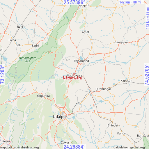
Nāthdwāra GPS coordinates[2]
24° 56' 16.98" North, 73° 49' 26.112" East
| Map corner | latitude | longitude |
|---|---|---|
| Upper-left | 25.57396°, | 73.1208° |
| Center: | 24.93805°, | 73.82392° |
| Lower-right: | 24.29884°, | 74.52705° |
| Map W x H: | 141.8×141.8 km | = 88.1×88.1mi |
| max Lat: | 34.9274° ⇑36.8% North |
| Nāthdwāra: | 24.93805° |
| min Lat: | ⇓63.2% South 8.09008° |
| min Long | Nāthdwāra | max Long |
| 68.82655° | 73.82392° | 96.81° |
| W 9%⇐ | ⇒91% E |
Elevation
Elevation of Nāthdwāra is 585 m = 1919 ft, and this is 289.4 m = 949 ft above average elevation for this country.
| Max E: |
3681 m = 12077 ft | 12.6% |
| Nāthdwāra | 585 m 1919 ft | |
| Avg. | 295.6 m = 970 ft | |
Min E: |
1 m = 3 ft | 87.4% |
See also: India elevation on elevation.city.
Geographical zone
Nāthdwāra is located in North temperate zone (between Tropic of Cancer and the Arctic Circle). Distance of this Northern Tropic circle is 166.9 km =103.7 mi to South.| Distance of | km | miles | from Nāthdwāra |
|---|---|---|---|
| North Pole | 7234.2 | 4495.1 | to North |
| Arctic Circle | 4628.3 | 2875.9 | to North |
| Tropic Cancer | 166.9 | 103.7 | to South |
| Equator | 2772.9 | 1723 | to South |


Nearby cities:
15 places around Nāthdwāra: (largest is in red/bold)
• Amet
42.2 km =26.2 mi,  14°
14°
• Bari Sādri
87.8 km =54.6 mi,  131°
131°
• Bhindār
60.7 km =37.7 mi,  142°
142°
• Bāli
60.9 km =37.8 mi,  298°
298°
• Chittaurgarh
80.9 km =50.3 mi,  93°
93°
• Dariba
31.3 km =19.4 mi, 87°
• Devgarh
65.8 km =40.9 mi, 7°
• Gangāpur
54 km =33.6 mi,  54°
54°
• Kānor
71.6 km =44.5 mi, 141°
• Pindwāra
79.1 km =49.2 mi,  258°
258°
• Rājsamand
15.9 km =9.9 mi,  20°
20°
• Rāni
69.2 km =43 mi,  311°
311°
• Sheoganj
79.4 km =49.3 mi,  286°
286°
• Sādri
46.4 km =28.8 mi, 306°
• Udaipur
40.7 km =25.3 mi,  195°
195°
Sources, notices
• [Note1] Compared only with cities in India existing in our database
• [Src1] Map data: © OpenStreetMap contributors (CC-BY-SA)
• [Src2] Other city data from geonames.org with taken over terms of usage.
• [Src3] Geographical zone / Annual Mean Temperature by Robert A. Rohde @ Wikipedia
