Sādri geodata
Sādri (Rajasthan) is a populated place; located in India in Asia/Kolkata (GMT+5.5) time zone. With population of 25,632 people, there are 1659 cities with bigger population in this country. Compared to other cities in India, 64.4% of cities are located further ↓South; 92.8% of cities are located further →East and 72.8% of cities have lower elevation than Sādri. Note1


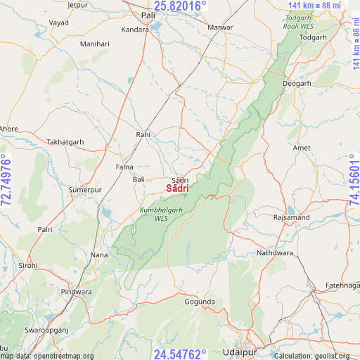
Sādri GPS coordinates[2]
25° 11' 7.98" North, 73° 27' 10.368" East
| Map corner | latitude | longitude |
|---|---|---|
| Upper-left | 25.82016°, | 72.74976° |
| Center: | 25.18555°, | 73.45288° |
| Lower-right: | 24.54762°, | 74.15601° |
| Map W x H: | 141.5×141.5 km | = 87.9×87.9mi |
| max Lat: | 34.9274° ⇑35.6% North |
| Sādri: | 25.18555° |
| min Lat: | ⇓64.4% South 8.09008° |
| min Long | Sādri | max Long |
| 68.82655° | 73.45288° | 96.81° |
| W 7.2%⇐ | ⇒92.8% E |
Elevation
Elevation of Sādri is 360 m = 1181 ft, and this is 64.4 m = 211 ft above average elevation for this country.
| Max E: |
3681 m = 12077 ft | 27.2% |
| Sādri | 360 m 1181 ft | |
| Avg. | 295.6 m = 970 ft | |
Min E: |
1 m = 3 ft | 72.8% |
See also: India elevation on elevation.city.
Geographical zone
Sādri is located in North temperate zone (between Tropic of Cancer and the Arctic Circle). Distance of this Northern Tropic circle is 194.5 km =120.9 mi to South.| Distance of | km | miles | from Sādri |
|---|---|---|---|
| North Pole | 7206.7 | 4478 | to North |
| Arctic Circle | 4600.8 | 2858.8 | to North |
| Tropic Cancer | 194.5 | 120.9 | to South |
| Equator | 2800.4 | 1740.1 | to South |


Nearby cities:
15 places around Sādri: (largest is in red/bold)
• Amet
49.4 km =30.7 mi,  74°
74°
• Bāli
16.3 km =10.1 mi,  274°
274°
• Dariba
73.5 km =45.7 mi,  110°
110°
• Devgarh
59.3 km =36.8 mi,  50°
50°
• Gangāpur
81.3 km =50.5 mi,  87°
87°
• Nāthdwāra
46.4 km =28.8 mi,  126°
126°
• Pindwāra
58.9 km =36.6 mi,  222°
222°
• Pāli
66.6 km =41.4 mi,  348°
348°
• Rājsamand
44.8 km =27.8 mi, 106°
• Rāni
23.4 km =14.5 mi,  321°
321°
• Sheoganj
39.1 km =24.3 mi,  262°
262°
• Sirohi
69.3 km =43.1 mi,  241°
241°
• Sojat
85 km =52.8 mi,  14°
14°
• Takhatgarh
47.6 km =29.6 mi,  288°
288°
• Udaipur
71.7 km =44.6 mi,  158°
158°
Sources, notices
• [Note1] Compared only with cities in India existing in our database
• [Src1] Map data: © OpenStreetMap contributors (CC-BY-SA)
• [Src2] Other city data from geonames.org with taken over terms of usage.
• [Src3] Geographical zone / Annual Mean Temperature by Robert A. Rohde @ Wikipedia
