Shimla geodata
Shimla (Himachal Pradesh) is a seat of a first-order administrative division; located in India in Asia/Kolkata (GMT+5.5) time zone. With population of 173,503 people, there are 247 cities with bigger population in this country. Compared to other cities in India, 96% of cities are located further ↓South; 61.4% of cities are located further →East and 99.3% of cities have lower elevation than Shimla. Note1


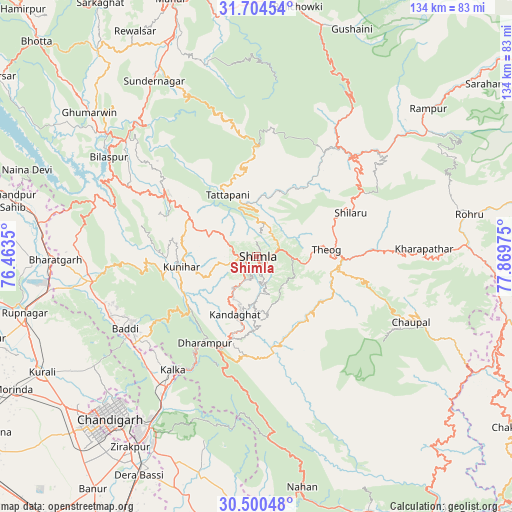
Shimla GPS coordinates[2]
31° 6' 15.912" North, 77° 9' 59.832" East
| Map corner | latitude | longitude |
|---|---|---|
| Upper-left | 31.70454°, | 76.4635° |
| Center: | 31.10442°, | 77.16662° |
| Lower-right: | 30.50048°, | 77.86975° |
| Map W x H: | 133.9×133.9 km | = 83.2×83.2mi |
| max Lat: | 34.9274° ⇑4% North |
| Shimla: | 31.10442° |
| min Lat: | ⇓96% South 8.09008° |
| min Long | Shimla | max Long |
| 68.82655° | 77.16662° | 96.81° |
| W 38.6%⇐ | ⇒61.4% E |
Elevation
Elevation of Shimla is 2073 m = 6801 ft, and this is 1777.4 m = 5831 ft above average elevation for this country.
| Max E: |
3681 m = 12077 ft | 0.7% |
| Shimla | 2073 m 6801 ft | |
| Avg. | 295.6 m = 970 ft | |
Min E: |
1 m = 3 ft | 99.3% |
See also: Shimla elevation on elevation.city.
Geographical zone
Shimla is located in North temperate zone (between Tropic of Cancer and the Arctic Circle). Distance of this Northern Tropic circle is 852.6 km =529.8 mi to South.| Distance of | km | miles | from Shimla |
|---|---|---|---|
| North Pole | 6548.6 | 4069.1 | to North |
| Arctic Circle | 3942.7 | 2449.9 | to North |
| Tropic Cancer | 852.6 | 529.8 | to South |
| Equator | 3458.5 | 2149 | to South |


Nearby cities:
15 places around Shimla: (largest is in red/bold)
• Arki
19.7 km =12.2 mi,  285°
285°
• Baddi
39.3 km =24.4 mi,  245°
245°
• Dagshai
26.8 km =16.7 mi,  204°
204°
• Jutogh
4.8 km =3 mi,  264°
264°
• Kasauli
29.8 km =18.5 mi,  219°
219°
• Kotkhai
35.5 km =22.1 mi,  87°
87°
• Kālka
36.5 km =22.7 mi, 216°
• Nārkanda
32.8 km =20.4 mi,  58°
58°
• Parwanoo
35.6 km =22.1 mi,  213°
213°
• Pinjaur
41.4 km =25.7 mi, 214°
• Rājgarh
30.9 km =19.2 mi,  155°
155°
• Sabāthu
22 km =13.7 mi,  229°
229°
• Seoni
15.8 km =9.8 mi,  345°
345°
• Solan
22.4 km =13.9 mi,  194°
194°
• Theog
18.4 km =11.4 mi,  84°
84°
Sources, notices
• [Note1] Compared only with cities in India existing in our database
• [Src1] Map data: © OpenStreetMap contributors (CC-BY-SA)
• [Src2] Other city data from geonames.org with taken over terms of usage.
• [Src3] Geographical zone / Annual Mean Temperature by Robert A. Rohde @ Wikipedia
