Sūrajgarh geodata
Sūrajgarh (Rajasthan) is a populated place; located in India in Asia/Kolkata (GMT+5.5) time zone. With population of 19,721 people, there are 2059 cities with bigger population in this country. Compared to other cities in India, 86% of cities are located further ↓South; 76.4% of cities are located further →East and 66.5% of cities have lower elevation than Sūrajgarh. Note1


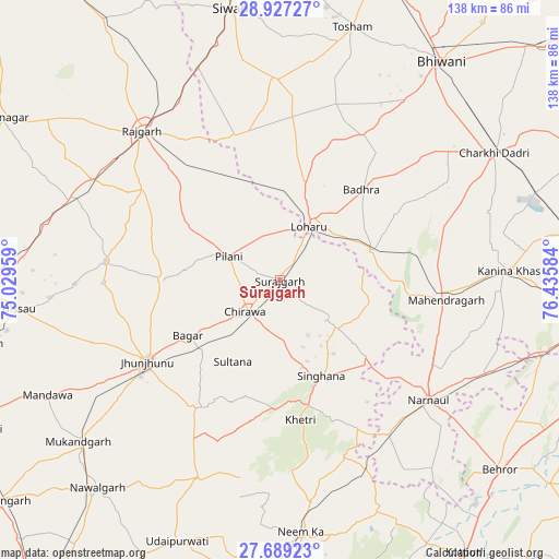
Sūrajgarh GPS coordinates[2]
28° 18' 36.18" North, 75° 43' 57.756" East
| Map corner | latitude | longitude |
|---|---|---|
| Upper-left | 28.92727°, | 75.02959° |
| Center: | 28.31005°, | 75.73271° |
| Lower-right: | 27.68923°, | 76.43584° |
| Map W x H: | 137.7×137.7 km | = 85.6×85.6mi |
| max Lat: | 34.9274° ⇑14% North |
| Sūrajgarh: | 28.31005° |
| min Lat: | ⇓86% South 8.09008° |
| min Long | Sūrajgarh | max Long |
| 68.82655° | 75.73271° | 96.81° |
| W 23.6%⇐ | ⇒76.4% E |
Elevation
Elevation of Sūrajgarh is 298 m = 978 ft, and this is 2.4 m = 8 ft above average elevation for this country.
| Max E: |
3681 m = 12077 ft | 33.5% |
| Sūrajgarh | 298 m 978 ft | |
| Avg. | 295.6 m = 970 ft | |
Min E: |
1 m = 3 ft | 66.5% |
See also: India elevation on elevation.city.
Geographical zone
Sūrajgarh is located in North temperate zone (between Tropic of Cancer and the Arctic Circle). Distance of this Northern Tropic circle is 541.9 km =336.7 mi to South.| Distance of | km | miles | from Sūrajgarh |
|---|---|---|---|
| North Pole | 6859.3 | 4262.2 | to North |
| Arctic Circle | 4253.4 | 2642.9 | to North |
| Tropic Cancer | 541.9 | 336.7 | to South |
| Equator | 3147.8 | 1956 | to South |


Nearby cities:
15 places around Sūrajgarh: (largest is in red/bold)
• Ateli Mandi
56.6 km =35.2 mi,  114°
114°
• Bagar
26.5 km =16.5 mi,  239°
239°
• Bissāu
64.6 km =40.1 mi,  263°
263°
• Charkhi Dādri
61.3 km =38.1 mi,  59°
59°
• Chidawa
12 km =7.5 mi,  229°
229°
• Jhunjhunūn
38.7 km =24 mi, 237°
• Kanīna Khās
56.7 km =35.2 mi,  87°
87°
• Khetri
34.8 km =21.6 mi,  171°
171°
• Lohāru
15.2 km =9.4 mi,  28°
28°
• Mahendragarh
41.4 km =25.7 mi,  96°
96°
• Mandholi Kalān
44.6 km =27.7 mi,  353°
353°
• Neem ka Thana
63.6 km =39.5 mi,  175°
175°
• Nārnaul
47.2 km =29.3 mi,  128°
128°
• Pilāni
14.2 km =8.8 mi,  296°
296°
• Rājgarh
50.1 km =31.1 mi,  317°
317°
Sources, notices
• [Note1] Compared only with cities in India existing in our database
• [Src1] Map data: © OpenStreetMap contributors (CC-BY-SA)
• [Src2] Other city data from geonames.org with taken over terms of usage.
• [Src3] Geographical zone / Annual Mean Temperature by Robert A. Rohde @ Wikipedia
