Baberu geodata
Baberu (Uttar Pradesh) is a populated place; located in India in Asia/Kolkata (GMT+5.5) time zone. With population of 15,607 people, there are 2407 cities with bigger population in this country. Compared to other cities in India, 67.2% of cities are located further ↓South; 71.7% of cities are located further ←West and 63.5% of cities have higher elevation than Baberu. Note1


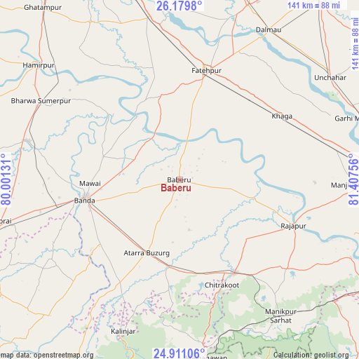
Baberu GPS coordinates[2]
25° 32' 49.596" North, 80° 42' 15.948" East
| Map corner | latitude | longitude |
|---|---|---|
| Upper-left | 26.1798°, | 80.00131° |
| Center: | 25.54711°, | 80.70443° |
| Lower-right: | 24.91106°, | 81.40756° |
| Map W x H: | 141.1×141.1 km | = 87.7×87.7mi |
| max Lat: | 34.9274° ⇑32.8% North |
| Baberu: | 25.54711° |
| min Lat: | ⇓67.2% South 8.09008° |
| min Long | Baberu | max Long |
| 68.82655° | 80.70443° | 96.81° |
| W 71.7%⇐ | ⇒28.3% E |
Elevation
Elevation of Baberu is 129 m = 423 ft, and this is 166.6 m = 547 ft below average elevation for this country.
| Max E: |
3681 m = 12077 ft | 63.5% |
| Avg. | 295.6 m = 970 ft | |
| Baberu | 129 m = 423 ft | |
Min E: |
1 m = 3 ft | 36.5% |
See also: India elevation on elevation.city.
Geographical zone
Baberu is located in North temperate zone (between Tropic of Cancer and the Arctic Circle). Distance of this Northern Tropic circle is 234.7 km =145.8 mi to South.| Distance of | km | miles | from Baberu |
|---|---|---|---|
| North Pole | 7166.5 | 4453.1 | to North |
| Arctic Circle | 4560.6 | 2833.8 | to North |
| Tropic Cancer | 234.7 | 145.8 | to South |
| Equator | 2840.6 | 1765.1 | to South |


Nearby cities:
15 places around Baberu: (largest is in red/bold)
• Atarra
31.9 km =19.8 mi,  204°
204°
• Bahua
33.5 km =20.8 mi,  345°
345°
• Bindki
55.9 km =34.7 mi, 346°
• Bisenda Buzurg
18.1 km =11.2 mi,  208°
208°
• Bānda
37.9 km =23.5 mi,  258°
258°
• Fatehpur
43.7 km =27.2 mi,  14°
14°
• Khāga
47.2 km =29.3 mi,  57°
57°
• Kishanpur
33.6 km =20.9 mi,  71°
71°
• Mataundh
56.4 km =35 mi, 257°
• Maudaha
61.1 km =38 mi,  284°
284°
• Naraini
45.9 km =28.5 mi, 210°
• Oran
20.2 km =12.6 mi,  169°
169°
• Rājāpur
48.2 km =30 mi,  111°
111°
• Sirāthu
62.5 km =38.8 mi,  80°
80°
• Tindwāri
19.4 km =12.1 mi,  293°
293°
Sources, notices
• [Note1] Compared only with cities in India existing in our database
• [Src1] Map data: © OpenStreetMap contributors (CC-BY-SA)
• [Src2] Other city data from geonames.org with taken over terms of usage.
• [Src3] Geographical zone / Annual Mean Temperature by Robert A. Rohde @ Wikipedia
