Hisar geodata
Hisar (Haryana) is a populated place; located in India in Asia/Kolkata (GMT+5.5) time zone. With population of 296,436 people, there are 147 cities with bigger population in this country. Compared to other cities in India, 89.6% of cities are located further ↓South; 76.4% of cities are located further →East and 52.6% of cities have lower elevation than Hisar. Note1


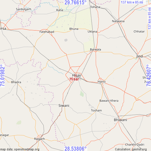
Hisar GPS coordinates[2]
29° 9' 14.184" North, 75° 43' 22.584" East
| Map corner | latitude | longitude |
|---|---|---|
| Upper-left | 29.76615°, | 75.01982° |
| Center: | 29.15394°, | 75.72294° |
| Lower-right: | 28.53806°, | 76.42607° |
| Map W x H: | 136.6×136.6 km | = 84.9×84.9mi |
| max Lat: | 34.9274° ⇑10.4% North |
| Hisar: | 29.15394° |
| min Lat: | ⇓89.6% South 8.09008° |
| min Long | Hisar | max Long |
| 68.82655° | 75.72294° | 96.81° |
| W 23.6%⇐ | ⇒76.4% E |
Elevation
Elevation of Hisar is 216 m = 709 ft, and this is 79.6 m = 261 ft below average elevation for this country.
| Max E: |
3681 m = 12077 ft | 47.4% |
| Avg. | 295.6 m = 970 ft | |
| Hisar | 216 m = 709 ft | |
Min E: |
1 m = 3 ft | 52.6% |
See also: Hisar elevation on elevation.city.
Geographical zone
Hisar is located in North temperate zone (between Tropic of Cancer and the Arctic Circle). Distance of this Northern Tropic circle is 635.7 km =395 mi to South.| Distance of | km | miles | from Hisar |
|---|---|---|---|
| North Pole | 6765.4 | 4203.8 | to North |
| Arctic Circle | 4159.6 | 2584.7 | to North |
| Tropic Cancer | 635.7 | 395 | to South |
| Equator | 3241.6 | 2014.2 | to South |


Nearby cities:
15 places around Hisar: (largest is in red/bold)
• Bara Uchāna
56.2 km =34.9 mi,  51°
51°
• Barwāla
29.8 km =18.5 mi,  37°
37°
• Bhiwāni
57 km =35.4 mi,  134°
134°
• Bhādra
53.9 km =33.5 mi,  263°
263°
• Fatehābād
47.8 km =29.7 mi,  327°
327°
• Gorakhpur
33 km =20.5 mi,  351°
351°
• Hānsi
24 km =14.9 mi,  103°
103°
• Inda Chhoi
54.5 km =33.9 mi,  6°
6°
• Jīnd
60.2 km =37.4 mi,  72°
72°
• Maham
59.3 km =36.8 mi,  110°
110°
• Mandholi Kalān
49.7 km =30.9 mi,  184°
184°
• Nārnaund
41.4 km =25.7 mi,  79°
79°
• Ratia
61.3 km =38.1 mi, 346°
• Toshām
36.8 km =22.9 mi,  149°
149°
• Uklāna
42.5 km =26.4 mi,  20°
20°
Sources, notices
• [Note1] Compared only with cities in India existing in our database
• [Src1] Map data: © OpenStreetMap contributors (CC-BY-SA)
• [Src2] Other city data from geonames.org with taken over terms of usage.
• [Src3] Geographical zone / Annual Mean Temperature by Robert A. Rohde @ Wikipedia
