Mandholi Kalān geodata
Mandholi Kalān (Haryana) is a populated place; located in India in Asia/Kolkata (GMT+5.5) time zone. With population of 4,500 people, there are 3360 cities with bigger population in this country. Compared to other cities in India, 87.9% of cities are located further ↓South; 76.7% of cities are located further →East and 56.9% of cities have lower elevation than Mandholi Kalān. Note1


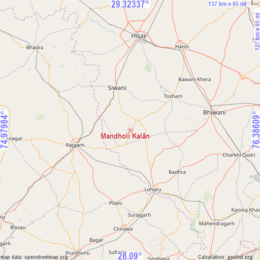
Mandholi Kalān GPS coordinates[2]
28° 42' 30.6" North, 75° 40' 58.656" East
| Map corner | latitude | longitude |
|---|---|---|
| Upper-left | 29.32337°, | 74.97984° |
| Center: | 28.7085°, | 75.68296° |
| Lower-right: | 28.09°, | 76.38609° |
| Map W x H: | 137.1×137.1 km | = 85.2×85.2mi |
| max Lat: | 34.9274° ⇑12.1% North |
| Mandholi Kalān: | 28.7085° |
| min Lat: | ⇓87.9% South 8.09008° |
| min Long | Mandholi Kalān | max Long |
| 68.82655° | 75.68296° | 96.81° |
| W 23.3%⇐ | ⇒76.7% E |
Elevation
Elevation of Mandholi Kalān is 234 m = 768 ft, and this is 61.6 m = 202 ft below average elevation for this country.
| Max E: |
3681 m = 12077 ft | 43.1% |
| Avg. | 295.6 m = 970 ft | |
| Mandholi Kalān | 234 m = 768 ft | |
Min E: |
1 m = 3 ft | 56.9% |
See also: India elevation on elevation.city.
Geographical zone
Mandholi Kalān is located in North temperate zone (between Tropic of Cancer and the Arctic Circle). Distance of this Northern Tropic circle is 586.2 km =364.2 mi to South.| Distance of | km | miles | from Mandholi Kalān |
|---|---|---|---|
| North Pole | 6815 | 4234.6 | to North |
| Arctic Circle | 4209.1 | 2615.4 | to North |
| Tropic Cancer | 586.2 | 364.2 | to South |
| Equator | 3192.1 | 1983.5 | to South |


Nearby cities:
15 places around Mandholi Kalān: (largest is in red/bold)
• Bagar
60.6 km =37.7 mi,  197°
197°
• Bhiwāni
45.5 km =28.3 mi,  78°
78°
• Bhādra
66.4 km =41.3 mi,  311°
311°
• Charkhi Dādri
58.9 km =36.6 mi,  102°
102°
• Chidawa
52.3 km =32.5 mi,  184°
184°
• Hisar
49.7 km =30.9 mi,  4°
4°
• Hānsi
51.6 km =32.1 mi,  31°
31°
• Lohāru
33.3 km =20.7 mi,  158°
158°
• Maham
66.3 km =41.2 mi,  64°
64°
• Mahendragarh
67 km =41.6 mi,  136°
136°
• Pilāni
38.7 km =24 mi,  191°
191°
• Rājgarh
29.9 km =18.6 mi,  255°
255°
• Sūrajgarh
44.6 km =27.7 mi,  173°
173°
• Toshām
29 km =18 mi,  51°
51°
• Tārānagar
63.6 km =39.5 mi,  266°
266°
Sources, notices
• [Note1] Compared only with cities in India existing in our database
• [Src1] Map data: © OpenStreetMap contributors (CC-BY-SA)
• [Src2] Other city data from geonames.org with taken over terms of usage.
• [Src3] Geographical zone / Annual Mean Temperature by Robert A. Rohde @ Wikipedia
