Pāli geodata
Pāli (Madhya Pradesh) is a populated place; located in India in Asia/Kolkata (GMT+5.5) time zone. With population of 21,287 people, there are 1952 cities with bigger population in this country. Compared to other cities in India, 54% of cities are located further ↓South; 73.1% of cities are located further ←West and 80.5% of cities have lower elevation than Pāli. Note1


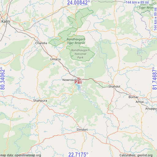
Pāli GPS coordinates[2]
23° 21' 52.308" North, 81° 2' 37.464" East
| Map corner | latitude | longitude |
|---|---|---|
| Upper-left | 24.00842°, | 80.34062° |
| Center: | 23.36453°, | 81.04374° |
| Lower-right: | 22.7175°, | 81.74687° |
| Map W x H: | 143.5×143.5 km | = 89.2×89.2mi |
| max Lat: | 34.9274° ⇑46% North |
| Pāli: | 23.36453° |
| min Lat: | ⇓54% South 8.09008° |
| min Long | Pāli | max Long |
| 68.82655° | 81.04374° | 96.81° |
| W 73.1%⇐ | ⇒26.9% E |
Elevation
Elevation of Pāli is 467 m = 1532 ft, and this is 171.4 m = 562 ft above average elevation for this country.
| Max E: |
3681 m = 12077 ft | 19.5% |
| Pāli | 467 m 1532 ft | |
| Avg. | 295.6 m = 970 ft | |
Min E: |
1 m = 3 ft | 80.5% |
See also: India elevation on elevation.city.
Geographical zone
Pāli is located in North Torrid zone (between Equator and Tropic of Cancer). Distance of this Northern Tropic circle is 8 km =5 mi to North.| Distance of | km | miles | from Pāli |
|---|---|---|---|
| North Pole | 7409.2 | 4603.9 | to North |
| Arctic Circle | 4803.3 | 2984.6 | to North |
| Tropic Cancer | 8 | 5 | to North |
| Equator | 2597.9 | 1614.3 | to South |


Nearby cities:
15 places around Pāli: (largest is in red/bold)
• Anūppur
72.2 km =44.9 mi,  113°
113°
• Barhi
64.3 km =40 mi,  338°
338°
• Beohāri
80.9 km =50.3 mi,  24°
24°
• Bodri
45.5 km =28.3 mi,  119°
119°
• Burhar
52.6 km =32.7 mi, 108°
• Chandia
47.1 km =29.3 mi,  313°
313°
• Dindori
47.2 km =29.3 mi,  175°
175°
• Jaisinghnagar
50.3 km =31.3 mi,  44°
44°
• Kotma
97.2 km =60.4 mi,  100°
100°
• Maihar
104.3 km =64.8 mi, 343°
• Murwāra
84.6 km =52.6 mi, 308°
• Shahdol
33.4 km =20.8 mi, 103°
• Shāhpur
38 km =23.6 mi,  186°
186°
• Sihorā
96.8 km =60.1 mi,  278°
278°
• Umaria
27.6 km =17.1 mi, 310°
Sources, notices
• [Note1] Compared only with cities in India existing in our database
• [Src1] Map data: © OpenStreetMap contributors (CC-BY-SA)
• [Src2] Other city data from geonames.org with taken over terms of usage.
• [Src3] Geographical zone / Annual Mean Temperature by Robert A. Rohde @ Wikipedia
