Jaisinghnagar geodata
Jaisinghnagar (Madhya Pradesh) is a populated place; located in India in Asia/Kolkata (GMT+5.5) time zone. With population of 7,600 people, there are 3162 cities with bigger population in this country. Compared to other cities in India, 56% of cities are located further ↓South; 74.3% of cities are located further ←West and 78.9% of cities have lower elevation than Jaisinghnagar. Note1


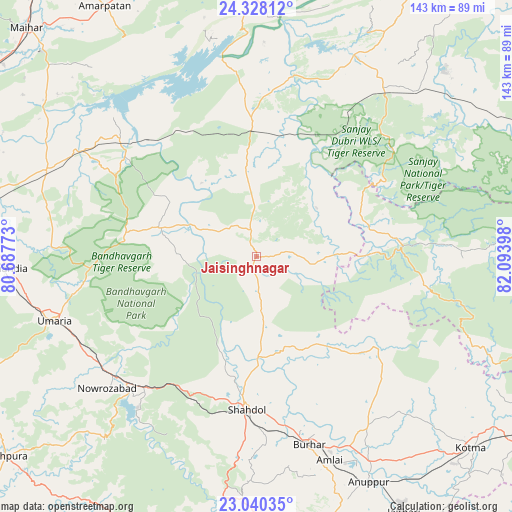
Jaisinghnagar GPS coordinates[2]
23° 41' 8.952" North, 81° 23' 27.06" East
| Map corner | latitude | longitude |
|---|---|---|
| Upper-left | 24.32812°, | 80.68773° |
| Center: | 23.68582°, | 81.39085° |
| Lower-right: | 23.04035°, | 82.09398° |
| Map W x H: | 143.2×143.2 km | = 89×89mi |
| max Lat: | 34.9274° ⇑44% North |
| Jaisinghnagar: | 23.68582° |
| min Lat: | ⇓56% South 8.09008° |
| min Long | Jaisinghnagar | max Long |
| 68.82655° | 81.39085° | 96.81° |
| W 74.3%⇐ | ⇒25.7% E |
Elevation
Elevation of Jaisinghnagar is 444 m = 1457 ft, and this is 148.4 m = 487 ft above average elevation for this country.
| Max E: |
3681 m = 12077 ft | 21.1% |
| Jaisinghnagar | 444 m 1457 ft | |
| Avg. | 295.6 m = 970 ft | |
Min E: |
1 m = 3 ft | 78.9% |
See also: India elevation on elevation.city.
Geographical zone
Jaisinghnagar is located in North temperate zone (between Tropic of Cancer and the Arctic Circle). Distance of this Northern Tropic circle is 27.7 km =17.2 mi to South.| Distance of | km | miles | from Jaisinghnagar |
|---|---|---|---|
| North Pole | 7373.4 | 4581.6 | to North |
| Arctic Circle | 4767.6 | 2962.4 | to North |
| Tropic Cancer | 27.7 | 17.2 | to South |
| Equator | 2633.6 | 1636.4 | to South |


Nearby cities:
15 places around Jaisinghnagar: (largest is in red/bold)
• Amarpātan
81.5 km =50.6 mi,  328°
328°
• Anūppur
71.6 km =44.5 mi,  154°
154°
• Barhi
63.4 km =39.4 mi,  292°
292°
• Beohāri
37.6 km =23.4 mi,  358°
358°
• Bodri
58 km =36 mi,  175°
175°
• Burhar
54.3 km =33.7 mi,  164°
164°
• Chandia
69.5 km =43.2 mi,  267°
267°
• Chorhat
87.2 km =54.2 mi,  18°
18°
• Dindori
88.7 km =55.1 mi,  200°
200°
• Govindgarh
77.6 km =48.2 mi,  352°
352°
• Kotma
80.5 km =50 mi,  131°
131°
• Pāli
50.3 km =31.3 mi,  224°
224°
• Shahdol
43.7 km =27.2 mi, 183°
• Shāhpur
83.5 km =51.9 mi,  208°
208°
• Umaria
59.2 km =36.8 mi,  252°
252°
Sources, notices
• [Note1] Compared only with cities in India existing in our database
• [Src1] Map data: © OpenStreetMap contributors (CC-BY-SA)
• [Src2] Other city data from geonames.org with taken over terms of usage.
• [Src3] Geographical zone / Annual Mean Temperature by Robert A. Rohde @ Wikipedia
