Umaria geodata
Umaria (Madhya Pradesh) is a populated place; located in India in Asia/Kolkata (GMT+5.5) time zone. With population of 29,740 people, there are 1459 cities with bigger population in this country. Compared to other cities in India, 55% of cities are located further ↓South; 72.4% of cities are located further ←West and 80.2% of cities have lower elevation than Umaria. Note1


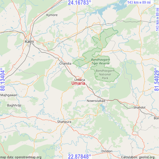
Umaria GPS coordinates[2]
23° 31' 29.028" North, 80° 50' 13.776" East
| Map corner | latitude | longitude |
|---|---|---|
| Upper-left | 24.16783°, | 80.13404° |
| Center: | 23.52473°, | 80.83716° |
| Lower-right: | 22.87848°, | 81.54029° |
| Map W x H: | 143.4×143.4 km | = 89.1×89.1mi |
| max Lat: | 34.9274° ⇑45% North |
| Umaria: | 23.52473° |
| min Lat: | ⇓55% South 8.09008° |
| min Long | Umaria | max Long |
| 68.82655° | 80.83716° | 96.81° |
| W 72.4%⇐ | ⇒27.6% E |
Elevation
Elevation of Umaria is 463 m = 1519 ft, and this is 167.4 m = 549 ft above average elevation for this country.
| Max E: |
3681 m = 12077 ft | 19.8% |
| Umaria | 463 m 1519 ft | |
| Avg. | 295.6 m = 970 ft | |
Min E: |
1 m = 3 ft | 80.2% |
See also: India elevation on elevation.city.
Geographical zone
Umaria is located in North temperate zone (between Tropic of Cancer and the Arctic Circle). Distance of this Northern Tropic circle is 9.8 km =6.1 mi to South.| Distance of | km | miles | from Umaria |
|---|---|---|---|
| North Pole | 7391.4 | 4592.8 | to North |
| Arctic Circle | 4785.5 | 2973.6 | to North |
| Tropic Cancer | 9.8 | 6.1 | to South |
| Equator | 2615.7 | 1625.3 | to South |


Nearby cities:
15 places around Umaria: (largest is in red/bold)
• Amarpātan
88.9 km =55.2 mi,  9°
9°
• Barhi
42.1 km =26.2 mi,  356°
356°
• Beohāri
78.2 km =48.6 mi,  44°
44°
• Bodri
72.8 km =45.2 mi,  123°
123°
• Burhar
78.8 km =49 mi, 115°
• Chandia
19.6 km =12.2 mi,  318°
318°
• Dindori
69.4 km =43.1 mi,  159°
159°
• Jaisinghnagar
59.2 km =36.8 mi,  72°
72°
• Maihar
82.8 km =51.4 mi,  354°
354°
• Murwāra
57 km =35.4 mi,  307°
307°
• Panāgar
90 km =55.9 mi,  252°
252°
• Pāli
27.6 km =17.1 mi,  130°
130°
• Shahdol
59.4 km =36.9 mi, 115°
• Shāhpur
58.2 km =36.2 mi, 162°
• Sihorā
74.9 km =46.5 mi,  266°
266°
Sources, notices
• [Note1] Compared only with cities in India existing in our database
• [Src1] Map data: © OpenStreetMap contributors (CC-BY-SA)
• [Src2] Other city data from geonames.org with taken over terms of usage.
• [Src3] Geographical zone / Annual Mean Temperature by Robert A. Rohde @ Wikipedia
