Manohar Thāna geodata
Manohar Thāna (Rajasthan) is a populated place; located in India in Asia/Kolkata (GMT+5.5) time zone. With population of 10,100 people, there are 2932 cities with bigger population in this country. Compared to other cities in India, 59.2% of cities are located further ↓South; 65% of cities are located further →East and 71.1% of cities have lower elevation than Manohar Thāna. Note1


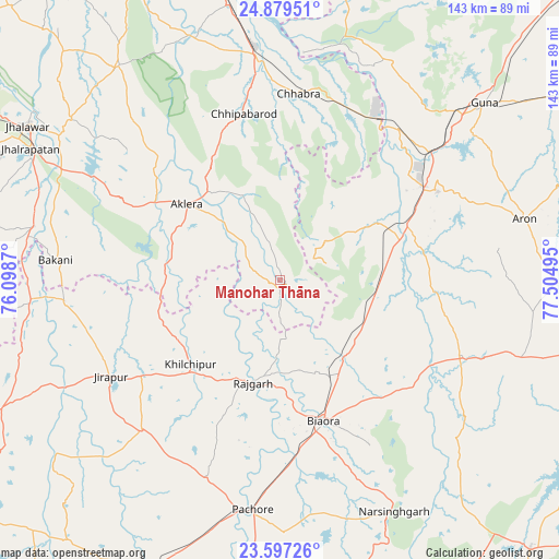
Manohar Thāna GPS coordinates[2]
24° 14' 24" North, 76° 48' 6.552" East
| Map corner | latitude | longitude |
|---|---|---|
| Upper-left | 24.87951°, | 76.0987° |
| Center: | 24.24°, | 76.80182° |
| Lower-right: | 23.59726°, | 77.50495° |
| Map W x H: | 142.6×142.6 km | = 88.6×88.6mi |
| max Lat: | 34.9274° ⇑40.8% North |
| Manohar Thāna: | 24.24° |
| min Lat: | ⇓59.2% South 8.09008° |
| min Long | Manohar Thāna | max Long |
| 68.82655° | 76.80182° | 96.81° |
| W 35%⇐ | ⇒65% E |
Elevation
Elevation of Manohar Thāna is 337 m = 1106 ft, and this is 41.4 m = 136 ft above average elevation for this country.
| Max E: |
3681 m = 12077 ft | 28.9% |
| Manohar Thāna | 337 m 1106 ft | |
| Avg. | 295.6 m = 970 ft | |
Min E: |
1 m = 3 ft | 71.1% |
See also: India elevation on elevation.city.
Geographical zone
Manohar Thāna is located in North temperate zone (between Tropic of Cancer and the Arctic Circle). Distance of this Northern Tropic circle is 89.3 km =55.5 mi to South.| Distance of | km | miles | from Manohar Thāna |
|---|---|---|---|
| North Pole | 7311.8 | 4543.3 | to North |
| Arctic Circle | 4705.9 | 2924.1 | to North |
| Tropic Cancer | 89.3 | 55.5 | to South |
| Equator | 2695.2 | 1674.7 | to South |


Nearby cities:
15 places around Manohar Thāna: (largest is in red/bold)
• Aklera
30.6 km =19 mi,  308°
308°
• Bakāni
57.5 km =35.7 mi,  275°
275°
• Biaora
37.2 km =23.1 mi,  162°
162°
• Chandpura
66.2 km =41.1 mi,  130°
130°
• Chhabra
47.4 km =29.5 mi,  5°
5°
• Khata Khedi
64.3 km =40 mi, 129°
• Khilchipur
31.8 km =19.8 mi,  225°
225°
• Khujner
53.8 km =33.4 mi,  200°
200°
• Kumbhrāj
29.1 km =18.1 mi,  59°
59°
• Leteri
64.7 km =40.2 mi,  108°
108°
• Māchalpur
50.8 km =31.6 mi,  255°
255°
• Narsinghgarh
66.2 km =41.1 mi,  153°
153°
• Rāghogarh
46 km =28.6 mi, 60°
• Rājgarh
26.7 km =16.6 mi, 195°
• Āron
64.3 km =40 mi,  75°
75°
Sources, notices
• [Note1] Compared only with cities in India existing in our database
• [Src1] Map data: © OpenStreetMap contributors (CC-BY-SA)
• [Src2] Other city data from geonames.org with taken over terms of usage.
• [Src3] Geographical zone / Annual Mean Temperature by Robert A. Rohde @ Wikipedia
