Chhabra geodata
Chhabra (Rajasthan) is a populated place; located in India in Asia/Kolkata (GMT+5.5) time zone. With population of 25,676 people, there are 1657 cities with bigger population in this country. Compared to other cities in India, 61.6% of cities are located further ↓South; 64.8% of cities are located further →East and 70.9% of cities have lower elevation than Chhabra. Note1


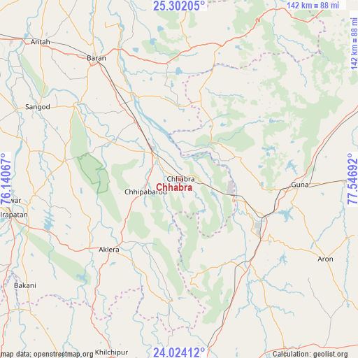
Chhabra GPS coordinates[2]
24° 39' 52.992" North, 76° 50' 37.644" East
| Map corner | latitude | longitude |
|---|---|---|
| Upper-left | 25.30205°, | 76.14067° |
| Center: | 24.66472°, | 76.84379° |
| Lower-right: | 24.02412°, | 77.54692° |
| Map W x H: | 142.1×142.1 km | = 88.3×88.3mi |
| max Lat: | 34.9274° ⇑38.4% North |
| Chhabra: | 24.66472° |
| min Lat: | ⇓61.6% South 8.09008° |
| min Long | Chhabra | max Long |
| 68.82655° | 76.84379° | 96.81° |
| W 35.2%⇐ | ⇒64.8% E |
Elevation
Elevation of Chhabra is 336 m = 1102 ft, and this is 40.4 m = 133 ft above average elevation for this country.
| Max E: |
3681 m = 12077 ft | 29.1% |
| Chhabra | 336 m 1102 ft | |
| Avg. | 295.6 m = 970 ft | |
Min E: |
1 m = 3 ft | 70.9% |
See also: India elevation on elevation.city.
Geographical zone
Chhabra is located in North temperate zone (between Tropic of Cancer and the Arctic Circle). Distance of this Northern Tropic circle is 136.5 km =84.8 mi to South.| Distance of | km | miles | from Chhabra |
|---|---|---|---|
| North Pole | 7264.6 | 4514 | to North |
| Arctic Circle | 4658.7 | 2894.8 | to North |
| Tropic Cancer | 136.5 | 84.8 | to South |
| Equator | 2742.5 | 1704.1 | to South |


Nearby cities:
15 places around Chhabra: (largest is in red/bold)
• Aklera
39.6 km =24.6 mi,  224°
224°
• Anta
76.9 km =47.8 mi,  314°
314°
• Bakāni
74.4 km =46.2 mi,  235°
235°
• Bārān
58.6 km =36.4 mi,  325°
325°
• Guna
47.3 km =29.4 mi,  92°
92°
• Jhālrapātan
69.2 km =43 mi,  258°
258°
• Jhālāwār
69 km =42.9 mi, 263°
• Khilchipur
74.6 km =46.4 mi,  201°
201°
• Khānpur
45.9 km =28.5 mi,  279°
279°
• Kumbhrāj
38.4 km =23.9 mi,  147°
147°
• Manohar Thāna
47.4 km =29.5 mi,  185°
185°
• Rāghogarh
43.4 km =27 mi,  124°
124°
• Rājgarh
73.9 km =45.9 mi, 188°
• Sangod
63.4 km =39.4 mi,  297°
297°
• Āron
66 km =41 mi, 118°
Sources, notices
• [Note1] Compared only with cities in India existing in our database
• [Src1] Map data: © OpenStreetMap contributors (CC-BY-SA)
• [Src2] Other city data from geonames.org with taken over terms of usage.
• [Src3] Geographical zone / Annual Mean Temperature by Robert A. Rohde @ Wikipedia
