Ambājogāi geodata
Ambājogāi (Maharashtra) is a populated place; located in India in Asia/Kolkata (GMT+5.5) time zone. With population of 74,114 people, there are 591 cities with bigger population in this country. Compared to other cities in India, 69.7% of cities are located further ↑North; 69.5% of cities are located further →East and 89.9% of cities have lower elevation than Ambājogāi. Note1


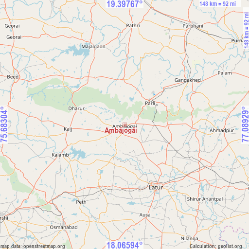
Ambājogāi GPS coordinates[2]
18° 43' 59.232" North, 76° 23' 10.176" East
| Map corner | latitude | longitude |
|---|---|---|
| Upper-left | 19.39767°, | 75.68304° |
| Center: | 18.73312°, | 76.38616° |
| Lower-right: | 18.06594°, | 77.08929° |
| Map W x H: | 148.1×148.1 km | = 92×92mi |
| max Lat: | 34.9274° ⇑69.7% North |
| Ambājogāi: | 18.73312° |
| min Lat: | ⇓30.3% South 8.09008° |
| min Long | Ambājogāi | max Long |
| 68.82655° | 76.38616° | 96.81° |
| W 30.5%⇐ | ⇒69.5% E |
Elevation
Elevation of Ambājogāi is 633 m = 2077 ft, and this is 337.4 m = 1107 ft above average elevation for this country.
| Max E: |
3681 m = 12077 ft | 10.1% |
| Ambājogāi | 633 m 2077 ft | |
| Avg. | 295.6 m = 970 ft | |
Min E: |
1 m = 3 ft | 89.9% |
See also: Ambājogāi elevation on elevation.city.
Geographical zone
Ambājogāi is located in North Torrid zone (between Equator and Tropic of Cancer). Distance of this Northern Tropic circle is 523 km =325 mi to North.| Distance of | km | miles | from Ambājogāi |
|---|---|---|---|
| North Pole | 7924.1 | 4923.8 | to North |
| Arctic Circle | 5318.2 | 3304.6 | to North |
| Tropic Cancer | 523 | 325 | to North |
| Equator | 2082.9 | 1294.3 | to South |


Nearby cities:
15 places around Ambājogāi: (largest is in red/bold)
• Ahmadpur
58.1 km =36.1 mi,  92°
92°
• Ashti
73.5 km =45.7 mi,  346°
346°
• Ausa
55.3 km =34.4 mi,  167°
167°
• Beed
72.1 km =44.8 mi,  293°
293°
• Dhārūr
30.7 km =19.1 mi, 288°
• Gangākher
46.4 km =28.8 mi,  55°
55°
• Latur
42 km =26.1 mi,  152°
152°
• Mājalgaon
51 km =31.7 mi,  338°
338°
• Mānwat
64.3 km =40 mi,  10°
10°
• Nilanga
78.7 km =48.9 mi, 150°
• Osmanabad
71.4 km =44.4 mi,  210°
210°
• Parbhani
72 km =44.7 mi,  34°
34°
• Parli Vaijnāth
20.1 km =12.5 mi,  49°
49°
• Pāthri
58.7 km =36.5 mi,  4°
4°
• Selu
80.5 km =50 mi, 4°
Sources, notices
• [Note1] Compared only with cities in India existing in our database
• [Src1] Map data: © OpenStreetMap contributors (CC-BY-SA)
• [Src2] Other city data from geonames.org with taken over terms of usage.
• [Src3] Geographical zone / Annual Mean Temperature by Robert A. Rohde @ Wikipedia
