Parbhani geodata
Parbhani (Maharashtra) is a populated place; located in India in Asia/Kolkata (GMT+5.5) time zone. With population of 289,629 people, there are 153 cities with bigger population in this country. Compared to other cities in India, 67.6% of cities are located further ↑North; 65.5% of cities are located further →East and 77.4% of cities have lower elevation than Parbhani. Note1


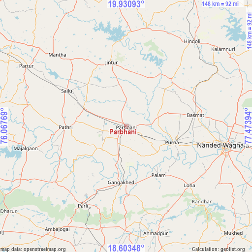
Parbhani GPS coordinates[2]
19° 16' 6.78" North, 76° 46' 14.916" East
| Map corner | latitude | longitude |
|---|---|---|
| Upper-left | 19.93093°, | 76.06769° |
| Center: | 19.26855°, | 76.77081° |
| Lower-right: | 18.60348°, | 77.47394° |
| Map W x H: | 147.6×147.6 km | = 91.7×91.7mi |
| max Lat: | 34.9274° ⇑67.6% North |
| Parbhani: | 19.26855° |
| min Lat: | ⇓32.4% South 8.09008° |
| min Long | Parbhani | max Long |
| 68.82655° | 76.77081° | 96.81° |
| W 34.5%⇐ | ⇒65.5% E |
Elevation
Elevation of Parbhani is 421 m = 1381 ft, and this is 125.4 m = 411 ft above average elevation for this country.
| Max E: |
3681 m = 12077 ft | 22.6% |
| Parbhani | 421 m 1381 ft | |
| Avg. | 295.6 m = 970 ft | |
Min E: |
1 m = 3 ft | 77.4% |
See also: Parbhani elevation on elevation.city.
Geographical zone
Parbhani is located in North Torrid zone (between Equator and Tropic of Cancer). Distance of this Northern Tropic circle is 463.5 km =288 mi to North.| Distance of | km | miles | from Parbhani |
|---|---|---|---|
| North Pole | 7864.6 | 4886.8 | to North |
| Arctic Circle | 5258.7 | 3267.6 | to North |
| Tropic Cancer | 463.5 | 288 | to North |
| Equator | 2142.5 | 1331.3 | to South |


Nearby cities:
15 places around Parbhani: (largest is in red/bold)
• Ahmadpur
64.9 km =40.3 mi,  164°
164°
• Ambājogāi
72 km =44.7 mi,  214°
214°
• Ashti
58.5 km =36.4 mi,  281°
281°
• Basmat
41.1 km =25.5 mi,  80°
80°
• Gangākher
33.3 km =20.7 mi,  183°
183°
• Hingoli
63.1 km =39.2 mi,  38°
38°
• Jintūr
39.2 km =24.4 mi,  347°
347°
• Mājalgaon
60.3 km =37.5 mi,  258°
258°
• Mānwat
28.9 km =18 mi, 277°
• Nanded
58.4 km =36.3 mi,  101°
101°
• Parli Vaijnāth
52.8 km =32.8 mi, 208°
• Partūr
68.9 km =42.8 mi,  302°
302°
• Pāthri
35.4 km =22 mi,  268°
268°
• Pūrna
28.4 km =17.6 mi,  109°
109°
• Selu
40.4 km =25.1 mi, 300°
Sources, notices
• [Note1] Compared only with cities in India existing in our database
• [Src1] Map data: © OpenStreetMap contributors (CC-BY-SA)
• [Src2] Other city data from geonames.org with taken over terms of usage.
• [Src3] Geographical zone / Annual Mean Temperature by Robert A. Rohde @ Wikipedia
