Beed geodata
Beed (Maharashtra) is a seat of a third-order administrative division; located in India in Asia/Kolkata (GMT+5.5) time zone. In our database, there are 3475 cities with bigger population. Compared to other cities in India, 68.6% of cities are located further ↑North; 76.2% of cities are located further →East and 83.2% of cities have lower elevation than Beed. Note1


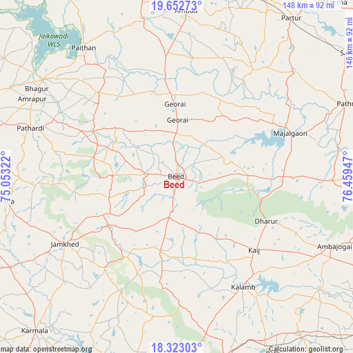
Beed GPS coordinates[2]
18° 59' 21.156" North, 75° 45' 22.824" East
| Map corner | latitude | longitude |
|---|---|---|
| Upper-left | 19.65273°, | 75.05322° |
| Center: | 18.98921°, | 75.75634° |
| Lower-right: | 18.32303°, | 76.45947° |
| Map W x H: | 147.8×147.9 km | = 91.8×91.9mi |
| max Lat: | 34.9274° ⇑68.6% North |
| Beed: | 18.98921° |
| min Lat: | ⇓31.4% South 8.09008° |
| min Long | Beed | max Long |
| 68.82655° | 75.75634° | 96.81° |
| W 23.8%⇐ | ⇒76.2% E |
Elevation
Elevation of Beed is 512 m = 1680 ft, and this is 216.4 m = 710 ft above average elevation for this country.
| Max E: |
3681 m = 12077 ft | 16.8% |
| Beed | 512 m 1680 ft | |
| Avg. | 295.6 m = 970 ft | |
Min E: |
1 m = 3 ft | 83.2% |
See also: India elevation on elevation.city.
Geographical zone
Beed is located in North Torrid zone (between Equator and Tropic of Cancer). Distance of this Northern Tropic circle is 494.5 km =307.3 mi to North.| Distance of | km | miles | from Beed |
|---|---|---|---|
| North Pole | 7895.7 | 4906.2 | to North |
| Arctic Circle | 5289.8 | 3286.9 | to North |
| Tropic Cancer | 494.5 | 307.3 | to North |
| Equator | 2111.4 | 1312 | to South |


Nearby cities:
15 places around Beed: (largest is in red/bold)
• Ambad
69.4 km =43.1 mi,  2°
2°
• Ambājogāi
72.1 km =44.8 mi,  113°
113°
• Ashti
65.4 km =40.6 mi,  48°
48°
• Bhūm
59.8 km =37.2 mi,  189°
189°
• Bārsi
84.2 km =52.3 mi,  184°
184°
• Dhārūr
41.6 km =25.8 mi,  116°
116°
• Gevrai
30.5 km =19 mi,  358°
358°
• Karmāla
87.7 km =54.5 mi,  222°
222°
• Mājalgaon
51.1 km =31.8 mi,  68°
68°
• Mānwat
85.2 km =52.9 mi, 65°
• Paithan
66.6 km =41.4 mi,  324°
324°
• Parli Vaijnāth
83 km =51.6 mi,  100°
100°
• Partūr
83.2 km =51.7 mi,  35°
35°
• Pāthardi
64.5 km =40.1 mi,  288°
288°
• Pāthri
77.3 km =48 mi, 67°
Sources, notices
• [Note1] Compared only with cities in India existing in our database
• [Src1] Map data: © OpenStreetMap contributors (CC-BY-SA)
• [Src2] Other city data from geonames.org with taken over terms of usage.
• [Src3] Geographical zone / Annual Mean Temperature by Robert A. Rohde @ Wikipedia
