Tanakpur geodata
Tanakpur (Uttarakhand) is a populated place; located in India in Asia/Kolkata (GMT+5.5) time zone. With population of 16,905 people, there are 2294 cities with bigger population in this country. Compared to other cities in India, 89.2% of cities are located further ↓South; 68.7% of cities are located further ←West and 62.1% of cities have lower elevation than Tanakpur. Note1


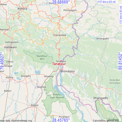
Tanakpur GPS coordinates[2]
29° 4' 26.4" North, 80° 6' 41.004" East
| Map corner | latitude | longitude |
|---|---|---|
| Upper-left | 29.68669°, | 79.40827° |
| Center: | 29.074°, | 80.11139° |
| Lower-right: | 28.45765°, | 80.81452° |
| Map W x H: | 136.7×136.7 km | = 84.9×84.9mi |
| max Lat: | 34.9274° ⇑10.8% North |
| Tanakpur: | 29.074° |
| min Lat: | ⇓89.2% South 8.09008° |
| min Long | Tanakpur | max Long |
| 68.82655° | 80.11139° | 96.81° |
| W 68.7%⇐ | ⇒31.3% E |
Elevation
Elevation of Tanakpur is 265 m = 869 ft, and this is 30.6 m = 100 ft below average elevation for this country.
| Max E: |
3681 m = 12077 ft | 37.9% |
| Avg. | 295.6 m = 970 ft | |
| Tanakpur | 265 m = 869 ft | |
Min E: |
1 m = 3 ft | 62.1% |
See also: India elevation on elevation.city.
Geographical zone
Tanakpur is located in North temperate zone (between Tropic of Cancer and the Arctic Circle). Distance of this Northern Tropic circle is 626.8 km =389.5 mi to South.| Distance of | km | miles | from Tanakpur |
|---|---|---|---|
| North Pole | 6774.3 | 4209.4 | to North |
| Arctic Circle | 4168.4 | 2590.1 | to North |
| Tropic Cancer | 626.8 | 389.5 | to South |
| Equator | 3232.7 | 2008.7 | to South |


Nearby cities:
15 places around Tanakpur: (largest is in red/bold)
• Baheri
68.4 km =42.5 mi,  240°
240°
• Banbasa
9.8 km =6.1 mi,  200°
200°
• Bhowali
68.5 km =42.6 mi,  300°
300°
• Bhīm Tāl
61.1 km =38 mi, 299°
• Champawat
29.2 km =18.1 mi,  353°
353°
• Haldwani
59 km =36.7 mi,  286°
286°
• Jahānābād
62.5 km =38.8 mi,  217°
217°
• Khatīma
21.8 km =13.5 mi, 218°
• Kichha
60.3 km =37.5 mi,  252°
252°
• Kālīnagar
50.5 km =31.4 mi,  183°
183°
• Lohaghāt
36.7 km =22.8 mi,  356°
356°
• Pithorāgarh
57.4 km =35.7 mi,  9°
9°
• Pīlibhīt
57.6 km =35.8 mi,  211°
211°
• Pūranpur
62.5 km =38.8 mi, 176°
• Sitārganj
42.7 km =26.5 mi, 247°
Sources, notices
• [Note1] Compared only with cities in India existing in our database
• [Src1] Map data: © OpenStreetMap contributors (CC-BY-SA)
• [Src2] Other city data from geonames.org with taken over terms of usage.
• [Src3] Geographical zone / Annual Mean Temperature by Robert A. Rohde @ Wikipedia
