Pithorāgarh geodata
Pithorāgarh (Uttarakhand) is a populated place; located in India in Asia/Kolkata (GMT+5.5) time zone. With population of 47,571 people, there are 926 cities with bigger population in this country. Compared to other cities in India, 91.5% of cities are located further ↓South; 69.7% of cities are located further ←West and 98.1% of cities have lower elevation than Pithorāgarh. Note1


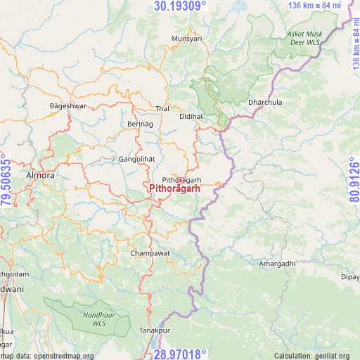
Pithorāgarh GPS coordinates[2]
29° 35' 0.564" North, 80° 12' 34.092" East
| Map corner | latitude | longitude |
|---|---|---|
| Upper-left | 30.19309°, | 79.50635° |
| Center: | 29.58349°, | 80.20947° |
| Lower-right: | 28.97018°, | 80.9126° |
| Map W x H: | 136×136 km | = 84.5×84.5mi |
| max Lat: | 34.9274° ⇑8.5% North |
| Pithorāgarh: | 29.58349° |
| min Lat: | ⇓91.5% South 8.09008° |
| min Long | Pithorāgarh | max Long |
| 68.82655° | 80.20947° | 96.81° |
| W 69.7%⇐ | ⇒30.3% E |
Elevation
Elevation of Pithorāgarh is 1586 m = 5203 ft, and this is 1290.4 m = 4234 ft above average elevation for this country.
| Max E: |
3681 m = 12077 ft | 1.9% |
| Pithorāgarh | 1586 m 5203 ft | |
| Avg. | 295.6 m = 970 ft | |
Min E: |
1 m = 3 ft | 98.1% |
See also: Pithorāgarh elevation on elevation.city.
Geographical zone
Pithorāgarh is located in North temperate zone (between Tropic of Cancer and the Arctic Circle). Distance of this Northern Tropic circle is 683.5 km =424.7 mi to South.| Distance of | km | miles | from Pithorāgarh |
|---|---|---|---|
| North Pole | 6717.7 | 4174.2 | to North |
| Arctic Circle | 4111.8 | 2555 | to North |
| Tropic Cancer | 683.5 | 424.7 | to South |
| Equator | 3289.4 | 2043.9 | to South |


Nearby cities:
15 places around Pithorāgarh: (largest is in red/bold)
• Almora
53.2 km =33.1 mi,  271°
271°
• Banbasa
67.1 km =41.7 mi,  191°
191°
• Bhowali
71.5 km =44.4 mi,  252°
252°
• Bhīm Tāl
68 km =42.3 mi, 246°
• Bāgeshwar
50.8 km =31.6 mi,  303°
303°
• Champawat
30.4 km =18.9 mi,  204°
204°
• Dhārchula
41.9 km =26 mi,  45°
45°
• Dwārāhāt
78.6 km =48.8 mi,  285°
285°
• Haldwani
77.2 km =48 mi,  238°
238°
• Khatīma
77.2 km =48 mi, 197°
• Lohaghāt
23.1 km =14.4 mi,  210°
210°
• Naini Tāl
76.7 km =47.7 mi, 254°
• Rānikhet
75.4 km =46.9 mi, 274°
• Sitārganj
87.7 km =54.5 mi, 213°
• Tanakpur
57.4 km =35.7 mi, 189°
Sources, notices
• [Note1] Compared only with cities in India existing in our database
• [Src1] Map data: © OpenStreetMap contributors (CC-BY-SA)
• [Src2] Other city data from geonames.org with taken over terms of usage.
• [Src3] Geographical zone / Annual Mean Temperature by Robert A. Rohde @ Wikipedia
