Dibai geodata
Dibai (Uttar Pradesh) is a populated place; located in India in Asia/Kolkata (GMT+5.5) time zone. With population of 37,873 people, there are 1161 cities with bigger population in this country. Compared to other cities in India, 85.4% of cities are located further ↓South; 51.9% of cities are located further ←West and 50.5% of cities have higher elevation than Dibai. Note1


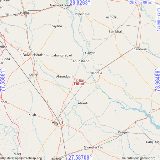
Dibai GPS coordinates[2]
28° 12' 30.564" North, 78° 15' 42.228" East
| Map corner | latitude | longitude |
|---|---|---|
| Upper-left | 28.8263°, | 77.55861° |
| Center: | 28.20849°, | 78.26173° |
| Lower-right: | 27.58708°, | 78.96486° |
| Map W x H: | 137.8×137.8 km | = 85.6×85.6mi |
| max Lat: | 34.9274° ⇑14.6% North |
| Dibai: | 28.20849° |
| min Lat: | ⇓85.4% South 8.09008° |
| min Long | Dibai | max Long |
| 68.82655° | 78.26173° | 96.81° |
| W 51.9%⇐ | ⇒48.1% E |
Elevation
Elevation of Dibai is 199 m = 653 ft, and this is 96.6 m = 317 ft below average elevation for this country.
| Max E: |
3681 m = 12077 ft | 50.5% |
| Avg. | 295.6 m = 970 ft | |
| Dibai | 199 m = 653 ft | |
Min E: |
1 m = 3 ft | 49.5% |
See also: India elevation on elevation.city.
Geographical zone
Dibai is located in North temperate zone (between Tropic of Cancer and the Arctic Circle). Distance of this Northern Tropic circle is 530.6 km =329.7 mi to South.| Distance of | km | miles | from Dibai |
|---|---|---|---|
| North Pole | 6870.6 | 4269.2 | to North |
| Arctic Circle | 4264.7 | 2650 | to North |
| Tropic Cancer | 530.6 | 329.7 | to South |
| Equator | 3136.5 | 1948.9 | to South |


Nearby cities:
15 places around Dibai: (largest is in red/bold)
• Alīgarh
40.7 km =25.3 mi,  206°
206°
• Anūpshahr
16.6 km =10.3 mi,  2°
2°
• Atraulī
20 km =12.4 mi,  173°
173°
• Babrāla
15.4 km =9.6 mi,  66°
66°
• Chharra
34.4 km =21.4 mi,  156°
156°
• Gawān
25.1 km =15.6 mi,  20°
20°
• Gunnaur
17.8 km =11.1 mi,  78°
78°
• Harduāganj
31.2 km =19.4 mi,  199°
199°
• Jahāngīrābād
26.7 km =16.6 mi,  325°
325°
• Jalālī
38 km =23.6 mi,  181°
181°
• Khurja
40.1 km =24.9 mi,  277°
277°
• Khānpur
41 km =25.5 mi, 332°
• Naraura
12.3 km =7.6 mi,  93°
93°
• Pahāsu
19.8 km =12.3 mi,  258°
258°
• Shikārpūr
25.5 km =15.8 mi,  288°
288°
Sources, notices
• [Note1] Compared only with cities in India existing in our database
• [Src1] Map data: © OpenStreetMap contributors (CC-BY-SA)
• [Src2] Other city data from geonames.org with taken over terms of usage.
• [Src3] Geographical zone / Annual Mean Temperature by Robert A. Rohde @ Wikipedia
