Pahāsu geodata
Pahāsu (Uttar Pradesh) is a populated place; located in India in Asia/Kolkata (GMT+5.5) time zone. With population of 18,854 people, there are 2140 cities with bigger population in this country. Compared to other cities in India, 85.2% of cities are located further ↓South; 50.7% of cities are located further →East and 51% of cities have higher elevation than Pahāsu. Note1


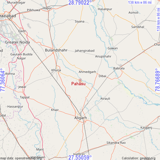
Pahāsu GPS coordinates[2]
28° 10' 19.92" North, 78° 3' 49.536" East
| Map corner | latitude | longitude |
|---|---|---|
| Upper-left | 28.79022°, | 77.36064° |
| Center: | 28.1722°, | 78.06376° |
| Lower-right: | 27.55059°, | 78.76689° |
| Map W x H: | 137.8×137.8 km | = 85.6×85.6mi |
| max Lat: | 34.9274° ⇑14.8% North |
| Pahāsu: | 28.1722° |
| min Lat: | ⇓85.2% South 8.09008° |
| min Long | Pahāsu | max Long |
| 68.82655° | 78.06376° | 96.81° |
| W 49.3%⇐ | ⇒50.7% E |
Elevation
Elevation of Pahāsu is 196 m = 643 ft, and this is 99.6 m = 327 ft below average elevation for this country.
| Max E: |
3681 m = 12077 ft | 51% |
| Avg. | 295.6 m = 970 ft | |
| Pahāsu | 196 m = 643 ft | |
Min E: |
1 m = 3 ft | 49% |
See also: India elevation on elevation.city.
Geographical zone
Pahāsu is located in North temperate zone (between Tropic of Cancer and the Arctic Circle). Distance of this Northern Tropic circle is 526.5 km =327.2 mi to South.| Distance of | km | miles | from Pahāsu |
|---|---|---|---|
| North Pole | 6874.6 | 4271.7 | to North |
| Arctic Circle | 4268.7 | 2652.4 | to North |
| Tropic Cancer | 526.5 | 327.2 | to South |
| Equator | 3132.5 | 1946.4 | to South |


Nearby cities:
15 places around Pahāsu: (largest is in red/bold)
• Alīgarh
32.3 km =20.1 mi,  178°
178°
• Anūpshahr
28.8 km =17.9 mi,  44°
44°
• Atraulī
26.9 km =16.7 mi,  126°
126°
• Babrāla
35 km =21.7 mi,  73°
73°
• Bulandshahr
32.7 km =20.3 mi,  321°
321°
• Dibai
19.8 km =12.3 mi,  78°
78°
• Gunnaur
37.6 km =23.4 mi, 78°
• Harduāganj
27 km =16.8 mi,  160°
160°
• Jahāngīrpur
35.2 km =21.9 mi,  271°
271°
• Jahāngīrābād
26.3 km =16.3 mi,  9°
9°
• Jalālī
38.7 km =24 mi,  151°
151°
• Khair
33.6 km =20.9 mi,  220°
220°
• Khurja
22.3 km =13.9 mi,  293°
293°
• Naraura
31.9 km =19.8 mi, 84°
• Shikārpūr
13 km =8.1 mi,  338°
338°
Sources, notices
• [Note1] Compared only with cities in India existing in our database
• [Src1] Map data: © OpenStreetMap contributors (CC-BY-SA)
• [Src2] Other city data from geonames.org with taken over terms of usage.
• [Src3] Geographical zone / Annual Mean Temperature by Robert A. Rohde @ Wikipedia
