Shikārpūr geodata
Shikārpūr (Uttar Pradesh) is a populated place; located in India in Asia/Kolkata (GMT+5.5) time zone. With population of 34,649 people, there are 1253 cities with bigger population in this country. Compared to other cities in India, 85.9% of cities are located further ↓South; 51.2% of cities are located further →East and 50.1% of cities have lower elevation than Shikārpūr. Note1


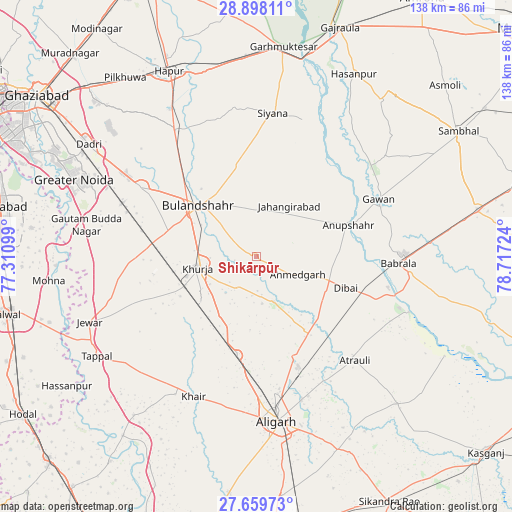
Shikārpūr GPS coordinates[2]
28° 16' 50.592" North, 78° 0' 50.796" East
| Map corner | latitude | longitude |
|---|---|---|
| Upper-left | 28.89811°, | 77.31099° |
| Center: | 28.28072°, | 78.01411° |
| Lower-right: | 27.65973°, | 78.71724° |
| Map W x H: | 137.7×137.7 km | = 85.6×85.6mi |
| max Lat: | 34.9274° ⇑14.1% North |
| Shikārpūr: | 28.28072° |
| min Lat: | ⇓85.9% South 8.09008° |
| min Long | Shikārpūr | max Long |
| 68.82655° | 78.01411° | 96.81° |
| W 48.8%⇐ | ⇒51.2% E |
Elevation
Elevation of Shikārpūr is 202 m = 663 ft, and this is 93.6 m = 307 ft below average elevation for this country.
| Max E: |
3681 m = 12077 ft | 49.9% |
| Avg. | 295.6 m = 970 ft | |
| Shikārpūr | 202 m = 663 ft | |
Min E: |
1 m = 3 ft | 50.1% |
See also: India elevation on elevation.city.
Geographical zone
Shikārpūr is located in North temperate zone (between Tropic of Cancer and the Arctic Circle). Distance of this Northern Tropic circle is 538.6 km =334.7 mi to South.| Distance of | km | miles | from Shikārpūr |
|---|---|---|---|
| North Pole | 6862.5 | 4264.2 | to North |
| Arctic Circle | 4256.7 | 2645 | to North |
| Tropic Cancer | 538.6 | 334.7 | to South |
| Equator | 3144.5 | 1953.9 | to South |


Nearby cities:
15 places around Shikārpūr: (largest is in red/bold)
• Anūpshahr
26.4 km =16.4 mi,  71°
71°
• Atraulī
38.6 km =24 mi,  136°
136°
• Babrāla
38.4 km =23.9 mi,  92°
92°
• Bulandshahr
20.5 km =12.7 mi,  311°
311°
• Dibai
25.5 km =15.8 mi,  108°
108°
• Gawān
36.5 km =22.7 mi,  64°
64°
• Harduāganj
40 km =24.9 mi,  159°
159°
• Jahāngīrpur
32.3 km =20.1 mi,  249°
249°
• Jahāngīrābād
16.5 km =10.3 mi,  32°
32°
• Khurja
15.8 km =9.8 mi,  259°
259°
• Khānpur
28.7 km =17.8 mi,  10°
10°
• Naraura
37.6 km =23.4 mi,  103°
103°
• Pahāsu
13 km =8.1 mi, 158°
• Saidpur
38.1 km =23.7 mi,  344°
344°
• Sikandarābād
36.2 km =22.5 mi,  301°
301°
Sources, notices
• [Note1] Compared only with cities in India existing in our database
• [Src1] Map data: © OpenStreetMap contributors (CC-BY-SA)
• [Src2] Other city data from geonames.org with taken over terms of usage.
• [Src3] Geographical zone / Annual Mean Temperature by Robert A. Rohde @ Wikipedia
