Ajodhya geodata
Ajodhya (Uttar Pradesh) is a populated place; located in India in Asia/Kolkata (GMT+5.5) time zone. With population of 53,293 people, there are 835 cities with bigger population in this country. Compared to other cities in India, 76.9% of cities are located further ↓South; 77.3% of cities are located further ←West and 68.1% of cities have higher elevation than Ajodhya. Note1


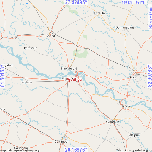
Ajodhya GPS coordinates[2]
26° 47' 56.724" North, 82° 12' 16.92" East
| Map corner | latitude | longitude |
|---|---|---|
| Upper-left | 27.42495°, | 81.50158° |
| Center: | 26.79909°, | 82.2047° |
| Lower-right: | 26.16976°, | 82.90783° |
| Map W x H: | 139.6×139.6 km | = 86.7×86.7mi |
| max Lat: | 34.9274° ⇑23.1% North |
| Ajodhya: | 26.79909° |
| min Lat: | ⇓76.9% South 8.09008° |
| min Long | Ajodhya | max Long |
| 68.82655° | 82.2047° | 96.81° |
| W 77.3%⇐ | ⇒22.7% E |
Elevation
Elevation of Ajodhya is 102 m = 335 ft, and this is 193.6 m = 635 ft below average elevation for this country.
| Max E: |
3681 m = 12077 ft | 68.1% |
| Avg. | 295.6 m = 970 ft | |
| Ajodhya | 102 m = 335 ft | |
Min E: |
1 m = 3 ft | 31.9% |
See also: Ajodhya elevation on elevation.city.
Geographical zone
Ajodhya is located in North temperate zone (between Tropic of Cancer and the Arctic Circle). Distance of this Northern Tropic circle is 373.9 km =232.3 mi to South.| Distance of | km | miles | from Ajodhya |
|---|---|---|---|
| North Pole | 7027.3 | 4366.6 | to North |
| Arctic Circle | 4421.4 | 2747.3 | to North |
| Tropic Cancer | 373.9 | 232.3 | to South |
| Equator | 2979.8 | 1851.6 | to South |


Nearby cities:
15 places around Ajodhya: (largest is in red/bold)
• Akbarpur
52.6 km =32.7 mi,  141°
141°
• Bastī
50.8 km =31.6 mi,  91°
91°
• Bīkāpur
23.8 km =14.8 mi,  197°
197°
• Colonelganj
62.5 km =38.8 mi,  306°
306°
• Dostpur
64 km =39.8 mi,  155°
155°
• Fyzābād
6 km =3.7 mi,  244°
244°
• Gondā City
44.6 km =27.7 mi,  326°
326°
• Goshāinganj
30.8 km =19.1 mi,  145°
145°
• Haraiya
25.8 km =16 mi, 91°
• Mankāpur
28.2 km =17.5 mi,  5°
5°
• Musāfir-Khāna
62 km =38.5 mi,  220°
220°
• Nawābganj
9.6 km =6 mi,  318°
318°
• Sultānpur
61.6 km =38.3 mi,  192°
192°
• Tāndā
52.9 km =32.9 mi,  121°
121°
• Utraula
61.6 km =38.3 mi,  20°
20°
In other languages:
- In France: Ayodhya
- In German: Ayodhya
- In Russian: Айодхье, Айодхья
- In Chinese: 阿约提亚
Sources, notices
• [Note1] Compared only with cities in India existing in our database
• [Src1] Map data: © OpenStreetMap contributors (CC-BY-SA)
• [Src2] Other city data from geonames.org with taken over terms of usage.
• [Src3] Geographical zone / Annual Mean Temperature by Robert A. Rohde @ Wikipedia
